This document presents the abstract design of the data model for the Planetary Data System Search Platform (PDSSP) within the STACPlanet framework.
The objective is to define an interoperable data model enabling the discovery, access, and reuse of planetary science data through modern open standards adopted by the scientific community.
The design is based on several complementary reference frameworks:
-
NASA’s Orbital Data Explorer (ODE) data model, widely used for planetary data indexing and search services.
-
The principles of Open Science, promoting accessibility, interoperability, and reusability of scientific data.
-
The Observation and Measurements (O&M) model defined by the Open Geospatial Consortium (OGC), providing a conceptual framework for representing scientific observations.
-
The SpatioTemporal Asset Catalog (STAC) standard, widely adopted for geospatial data discovery and metadata description.
-
The Europlanet Table Access Protocol (EPN-TAP) from the IVOA, which provides a standardized interface and data model for accessing planetary science data services.
The document first introduces the core concepts of the O&M model and its relevance for planetary science data representation. It then analyzes the NASA ODE data model in order to identify key entities and relationships required for planetary observation systems.
A conceptual mapping between O&M, EPN-TAP, and STAC is then proposed. This mapping translates observation concepts, procedures, observed phenomena, results, and target entities into STAC core constructs such as Catalogs, Collections, Items, and Assets, while aligning them with EPN-TAP parameterization principles and service-oriented access models.
Finally, the document defines the resulting STAC data model for PDSSP, which emerges from the convergence of NASA practices, OGC standards, IVOA EPN-TAP recommendations, and the STAC ecosystem.
This model forms the foundation of the STACPlanet architecture and aims to enable federated access to planetary datasets while ensuring semantic interoperability across modern scientific infrastructures.
STAC, STACPlanet, PDSSP, ODE, IVOA, EPN-TAP, OGC, O&M
List of Figures
This section lists all figures included in this document. Click a link to jump to the figure.
1. Acronyms
This section lists, in alphabetical order, the acronyms used throughout this document. Each occurrence of an acronym in the text links back to its definition here.
| Acronym | Definition |
|---|---|
Data Access Layer Interface |
|
Digital Elevation Model |
|
Digital Object Identifier |
|
Europlanet Table Access Protocol |
|
Findable, Accessible, Interoperable, Reusable |
|
Instrument Host Id |
|
Instrument Id |
|
International Virtual Observatory Alliance |
|
Julian Days |
|
Observations and Measurements |
|
Orbital Data Explorer |
|
Open Geospatial Consortium |
|
Observations, Measurements, and Samples |
|
Planetary Data System |
|
Planetary Surfaces Data and Services Pole |
|
W3C Provenance (data model and family of specifications) |
|
Product Type |
|
SpatioTemporal Asset Catalog |
|
Table Access Protocol |
|
Universal Worker Service |
2. General Context
In the current landscape of planetary research, the interoperability of data sets is an unavoidable requirement. Spatial programs and the massive publication of data volumes via the ODE service are on the rise. On the other hand, European researchers and archive services use the EPN-TAP model to describe and disseminate their data sets, while the DOI (Digital Object Identifier) ensures the permanence and citability of numerical resources.
Finally, the Open Science movement requires that these data be FAIR (Findable, Accessible, Interoperable, Reusable) (Wilkinson et al., 2016) in order to maximize their scientific and societal value.
2.1. FAIR Principles
The FAIR principles, originally defined by Wilkinson et al. (2016), are organized into four groups, each broken down into sub-criteria (source):
| Sub-criterion | Description |
|---|---|
Findable |
|
F1 |
(Meta)data are assigned a globally unique and persistent identifier. |
F2 |
Data are described with rich metadata. |
F3 |
Metadata clearly and explicitly include the identifier of the data they describe. |
F4 |
(Meta)data are registered or indexed in a searchable resource. |
Accessible |
|
A1 |
(Meta)data are retrievable by their identifier using a standardised communications protocol. |
A1.1 |
The protocol is open, free, and universally implementable. |
A1.2 |
The protocol allows for an authentication and authorisation procedure, where necessary. |
A2 |
Metadata are accessible, even when the data are no longer available. |
Interoperable |
|
I1 |
(Meta)data use a formal, accessible, shared, and broadly applicable language for knowledge representation. |
I2 |
(Meta)data use vocabularies that follow FAIR principles. |
I3 |
(Meta)data include qualified references to other (meta)data. |
Reusable |
|
R1 |
(Meta)data are richly described with a plurality of accurate and relevant attributes. |
R1.1 |
(Meta)data are released with a clear and accessible data usage license. |
R1.2 |
(Meta)data are associated with detailed provenance (W3C PROV-Overview, 2013). |
R1.3 |
(Meta)data meet domain-relevant community standards. |
|
FAIR and Open are complementary but distinct requirements, and PDSSP must satisfy both. Being FAIR does not automatically mean being Open: principle A1.2 above explicitly allows access to be gated behind authentication or authorization "where necessary," so a dataset can be fully FAIR while remaining access-restricted. For PDSSP data to genuinely support Open Science, it must therefore be:
|
2.2. STAC Planet data model constraints
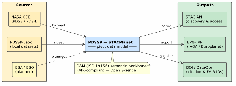
The Planetary Surfaces Data and Services Pole (PDSSP) must therefore be able to ingest the free products provided by NASA/ODE, transform them into a format compliant with EPN-TAP, assign them a DOI, and make them fully reusable within the Open Science ecosystem. This dual constraint—accepting a very specific input format and producing a set of heterogeneous outputs—requires a central data model that serves as a pivot between the different standards.
3. Objectives of the Document
The objectives of this document are as follows:
-
Define the data model of the Pole, structured as follows:
-
Illustrate each reference model (NASA/ODE, EPN-TAP, DOI, Open Science) and show how its concepts are projected onto the Pole’s model.
-
Compare the Pole’s model with the O&M standard (Observations & Measurements — ISO 19156), in order to:
-
Provide an internationally recognized reference framework;
-
Facilitate future extensions and exchanges with other communities that already use O&M.
-
4. Methodology
To ensure a rigorous comparison, each reference model will be summarized into three to five key elements (entities, attributes, relationships) and then mapped to the components of the Pole’s model using correspondence tables.
The O&M standard will be presented first in the document, as it constitutes the semantic anchor point: the Pole’s model is built as a specialization of O&M, enriched with fields required by NASA/ODE, EPN-TAP, DOI, and Open Science.
This "top-down" approach (from the generic O&M standard to the specifics of the Pole) ensures:
-
Conceptual coherence across all stages of the data value chain;
-
The possibility of extending the model further (e.g., adoption of other observation standards or new FAIR requirements).
5. Brief Overview of the O&M Standard
5.1. Observation & Measurement 2011
Observation & Measurements (O&M), jointly published by the Open Geospatial Consortium (OGC) and ISO under the ISO 19156:2011 reference, is a conceptual standard that defines a common schema for describing scientific observations and their results.
It is designed to be used in a wide variety of domains—meteorology, hydrology, oceanography, environmental sciences—and to facilitate the exchange of data between scientific and technical communities.
The standard provides a natural language definition that serves as a guide for the entire model:
An observation is the process by which an observer applies a specific procedure to estimate a property of a feature of interest and produces a result.
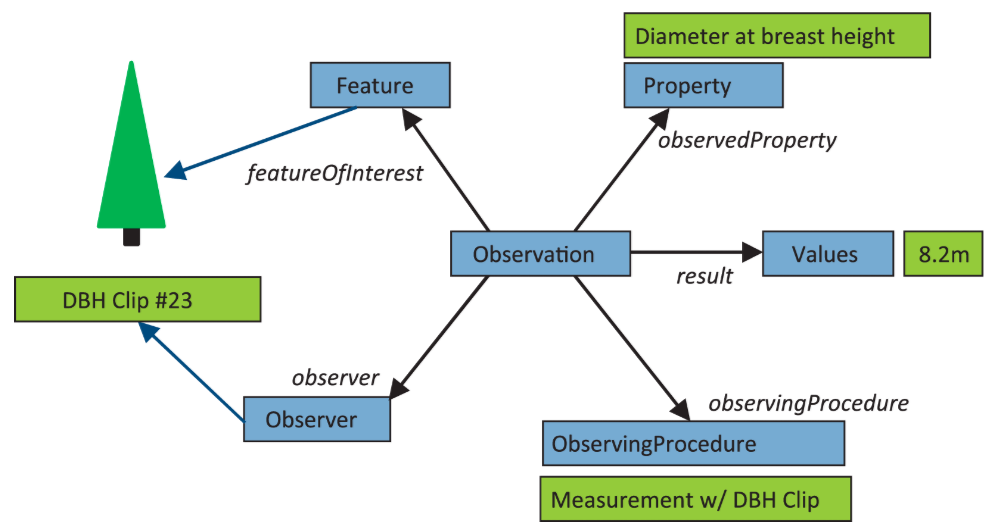
Each term in bold corresponds to a formal interface in the model.
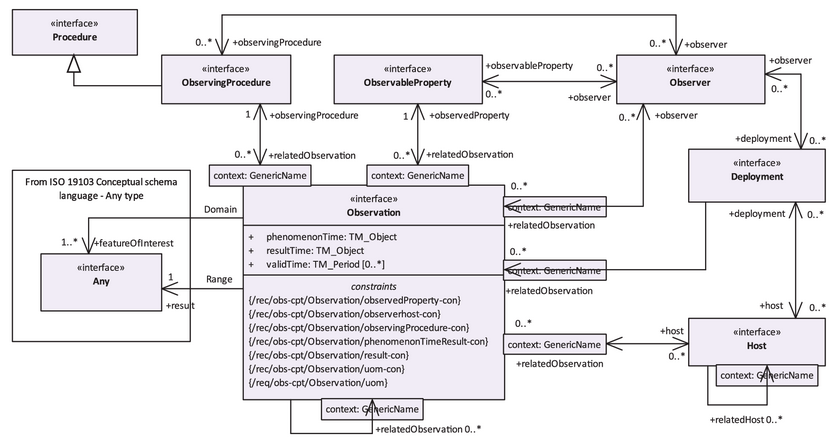
| Interface | Role | PDSSP example |
|---|---|---|
Observation |
The act of observing, located in time |
A THEMIS acquisition on July 5, 2002 |
FeatureOfInterest |
The real-world object whose property is observed |
The surface of Mars |
ObservableProperty |
The physical property being measured |
Brightness temperature in infrared |
Observer |
The instrument or sensor that measures |
THEMIS instrument |
Host |
The platform carrying the instrument |
Mars Odyssey spacecraft |
ObservingProcedure |
The method or processing chain applied |
Radiometric calibration (BTR) |
Deployment |
TODO |
TODO |
The Observation interface includes attributes that contextualize the act of observing in time and qualify its result:
| Attribute | Description |
|---|---|
phenomenonTime |
The moment when the observed phenomenon actually occurred |
resultTime |
The moment when the result was produced or recorded |
validTime |
The period during which the result is considered valid |
result |
The value produced by the observation (of type Any: number, text, image, etc.) |
resultQuality |
The quality or reliability of the result |
observationType |
The category of observation performed |
parameter |
Contextual parameters such as field of view angle, pressure, altitude |
The relationships to the five interfaces (featureOfInterest, observer, host, observingProcedure, observedProperty) are modeled as associations, not as attributes. This means that each entity has its own independent existence and can be shared among multiple observations.
5.2. Observation & Measurement 2023
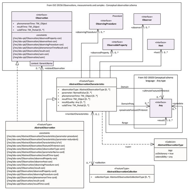
The revised ISO 19156:2023, jointly prepared with the Open Geospatial Consortium, introduces missing concepts from the previous version and provides clarifications on existing concepts and their relationships, while keeping the fundamental data model largely intact.
The 2011 version was primarily designed in the context of the OGC's Sensor Web Enablement, meaning it was intended for relatively homogeneous environmental sensor networks. Twelve years of use across much broader domains—planetary sciences, medicine, industrial IoT—revealed gaps and ambiguities that the 2023 revision addresses.
The name of the standard itself subtly reflects this evolution: it shifts from Observations and Measurements to Observations, Measurements, and Samples (OMS), signaling that physical samples are now a first-class concept in the model, rather than an appendix.
The 2011 conceptual schema is fully preserved. Any profile or implementation compliant with the 2011 version remains conceptually compatible with the 2023 version.
The Five Addressed Gaps:
-
Formal Collection Absence : In 2011, there was no formal way to indicate that a set of observations constituted a coherent whole with its own metadata—such as a measurement campaign, a time series, or a mission dataset. This gap forced each implementation to invent its own grouping concept, which was incompatible with others. The 2023 version introduces
AbstractObservationCollection, a class that groups observations and shares common characteristics with them viaAbstractObservationCharacteristics. -
Rigid Result Typing : In 2011, each result type required a dedicated subclass:
OM_Measurementfor a number,OM_CategoryObservationfor text, andOM_ComplexObservationfor a structure. This rigid hierarchy made extending the model complex and produced schemas that were difficult to maintain. The 2023 version adopts "soft-typing": the observation type is carried by anobservationTypeattribute rather than the class hierarchy, providing much more flexibility without losing expressiveness. -
Ambiguity of Feature of Interest : In scientific practice, an intermediate sample is often observed to learn something about a real object of interest. For example, a rover collects a fragment of Martian rock to analyze its mineralogical composition—the fragment is what is directly measured, while Mars is what is ultimately being characterized. In 2011, a single
featureOfInterestassociation did not allow distinguishing between these two levels. The 2023 version explicitly introducesproximateFeatureOfInterestfor the directly measured object andultimateFeatureOfInterestfor the final object of interest. -
Absence of Deployment : How to model that an instrument is installed on a platform at a given date, in a specific configuration, and then replaced or reconfigured? In 2011, the relationship between
ObserverandHostwas a simple association without temporality or parameterization. The 2023 version introducesDeploymentto formalize this link over time, which is essential for space missions or long-lived ground-based telescopes where instruments evolve. -
Redesign of Sample Types : In 2011,
SF_SamplingFeaturetypes were classified according to their topological dimension—point, curve, surface, or volume. This classification was suitable for terrestrial geospatial data but poorly adapted to experimental sciences in general. The 2023 version reclassifies samples according to their physical nature:SpatialSamplefor objects located in space,MaterialSamplefor physical ex-situ samples, andStatisticalSamplefor statistical populations. This classification is immediately understandable for a chemist, biologist, or planetary scientist.
6. Presentation of Reference Data Models
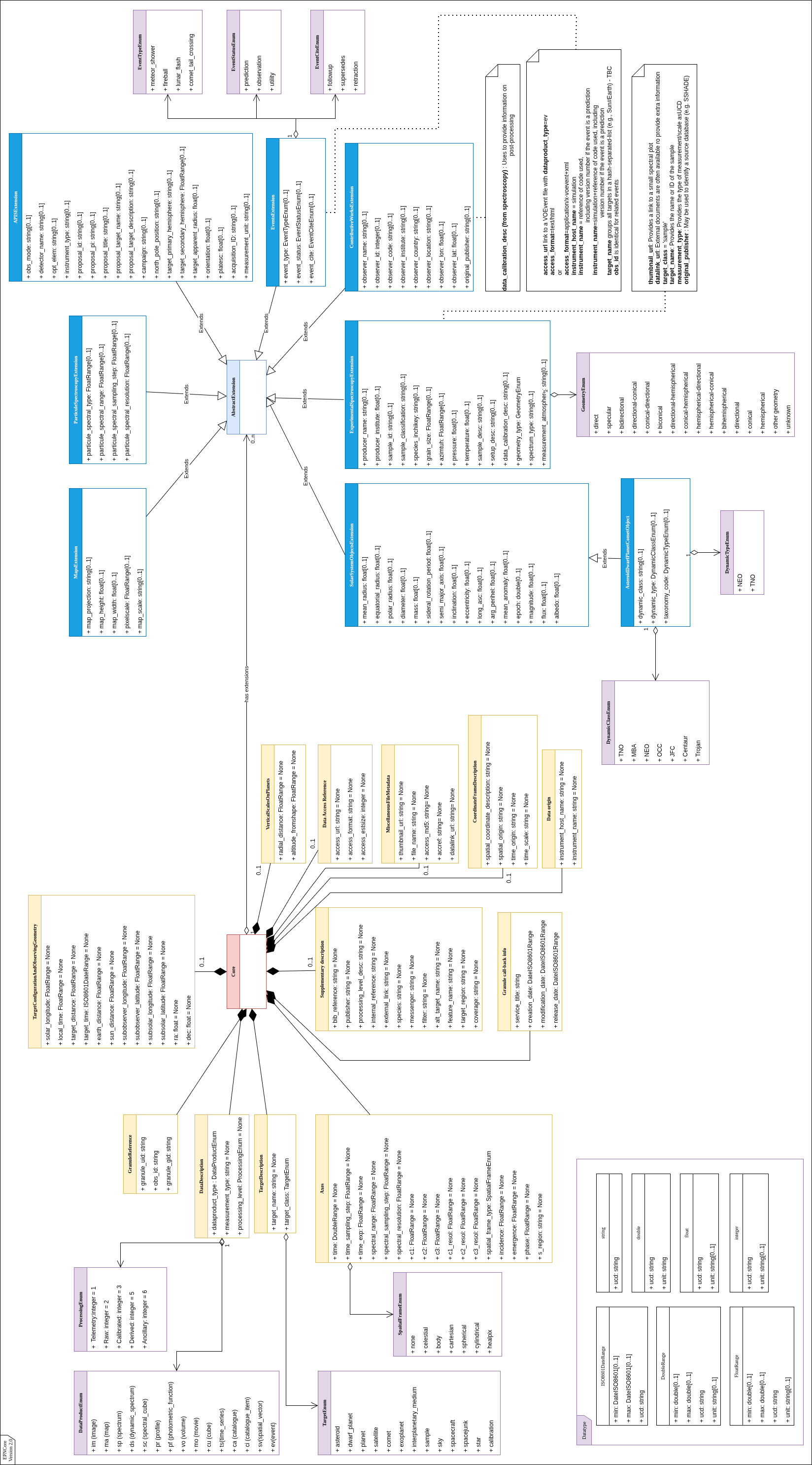
6.1. EPN Core
The EPN-TAP data model, a standard of the International Virtual Observatory Alliance (IVOA), is a comprehensive framework designed to facilitate the discovery and access of data related to the solar system. This model is integral to the EPN-TAP protocol, which extends the IVOA's Table Access Protocol (TAP) to provide standardized access to planetary science data.
The EPN-TAP data model includes the EPN-TAP metadata dictionary, which defines essential parameters for describing data products. These parameters cover various aspects such as temporal, spectral, spatial, and photometric characteristics, as well as the origin, content, and access methods of the data.
An EPN-TAP service consists of a single table that describes a list of granules using the metadata dictionary. Each granule corresponds to a row in the table, while each parameter corresponds to a column. Only one data product can be described and linked per row of the table, supporting observations, simulations, or experimental data.
The global philosophy of EPN-TAP is to describe all tables with a common set of mandatory parameters. This standardization allows for the seamless querying of multiple EPN-TAP services together, enhancing interoperability and data accessibility across different platforms and disciplines. Several independent services can reside on a single server, further promoting efficient data management and collaboration within the scientific community.
| Parameter | Description |
|---|---|
granule_uid |
Identifier for this row. This parameter is a primary key in |
obs_id |
Associates granules derived from the same data (e.g., various representations or processing levels). May be the ID of the original observation. |
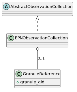
granule_gid |
Associates granules of the same type (e.g., same map projection, or geometry data products). Think of it as a simple and convenient way to group or differentiate types of data. When several files relate to the same data, this parameter helps distinguishing them. |
dataproduct_type |
Describes the high-level scientific organization of the data product linked by the |
measurement_type |
Defines the physical quantities contained in the data, using UCDs (Cecconi and Louys et al., 2021). It relates to the reported quantity, not to the type of experiment. Only UCDs related to physical quantities can be used (e.g., |
processing_level |
Provides a quick evaluation of data readiness level. EPN-TAP uses a simplified scheme. Several classifications are in use in different contexts. EPN-TAP uses the CODMAC/PDS3 levels but removes intermediate calibration levels. "Partially calibrated" data collections are generally considered as not calibrated. "Ancillary" data include extra information documenting the measurements. |
processing_level_desc |
Optional parameter to provide a specific encoding of processing levels related to a data collection, or more details about partial calibrations. |
target_name |
Identifies a target by name or ID. The target may be any Solar System body, exoplanet, planetary sample, or meteorite, plus in some cases astronomical objects or spacecraft. Alternative names of the same target must not be listed here but may be provided through the optional |
target_class |
Identifies the type of the target. Solar System bodies are defined without ambiguity by the couple |
time_min, time_max |
Provide the date and time of acquisition in the observer frame. Always provided in UTC and formatted in Julian Days (double precision). EPN-TAP uses standard JD to avoid ambiguity with time origin. Double precision floats ensure an accuracy on the order of 1 ms. |
time_sampling_step (min/max) |
Provide the sampling step in seconds for measurements of dynamical phenomena and computations. This is the time between 2 successive measurements or data, mostly relevant when the measurements are regularly spaced. |
time_exp (min/max) |
Correspond to the integration time (or exposure time) of measurements in seconds. Provide an estimate of the time resolution for dynamical phenomena, as well as an indication of relative S/N ratio inside a given data collection. |
spectral_range (min/max) |
Define the upper and lower bounds of the spectral domain of the data. Expressed on a frequency scale in Hertz. The spectral range and associated parameters only apply to electromagnetic waves. Recommended to fill even for images obtained through a filter. |
spectral_sampling_step (min/max) |
Provide the spectral separation between the centers of two adjacent filters or channels. Expressed on a frequency scale in Hz. Most relevant for radio observations with regular sampling. |
spectral_resolution (min/max) |
Provide the (dimensionless) resolving power λ/∆λ = ν/∆ν. Mostly intended to provide an order of magnitude, e.g., to distinguish between Fourier spectrometers, grating spectrometers, or filter cameras. |
c1 (min/max) |
Provide up to three spatial coordinates of the measured target. Coordinates depend on the |
c2 (min/max) |
- |
c3 (min/max) |
- |
c1_resol (min/max) |
Provide a simple estimate of the resolution in the same frame/units as c1/c2/c3. For instance, if |
c2_resol (min/max) |
- |
c3_resol (min/max) |
- |
spatial_frame_type |
2D angles in body-fixed frame: longitude c1 and latitude c2, plus possibly altitude as c3. A planetocentric system with eastward longitudes in the range (0, 360)° is required for service interoperability. IAU 2009 planetocentric convention applies. Parameter c3 is measured above the reference ellipsoid and can be <0 for interiors. |
incidence (min/max) |
Define the upper and lower bounds of the incidence angle range in the data (Solar Zenith Angle). Always indicated in decimal degrees, usually ranging from 0 to 90° (with 0° indicating the normal to the surface). |
emergence (min/max) |
Define the upper and lower bounds of the emergence, emission, or viewing angle range in the data. Always indicated in decimal degrees, usually ranging from 0 to 90° (with 0° indicating the normal to the surface). |
phase (min/max) |
Define the upper and lower bounds of the phase angle range in the data (scattering angle − 180°, or light source−target-observer angle). Always indicated in decimal degrees, may range from -180 to 180° (with 0° corresponding to opposition). |
s_region |
Introduces a footprint as a contour. Should be given for geolocalized data products in 2D, most notably on the sky (using RA, Dec) or on planetary surfaces (using E longitude, latitude). Coordinates are provided in the same reference system as c1/c2 parameters. |
coverage |
Introduces another type of footprint, with potential extension to time coverage. When both |
instrument_host_name |
Provides the name of the observatory, spacecraft, or facility that performed the measurements. A hash-separated-list of host names must be provided for integrated data sets. In the EPN-TAP table, the acronym is preferred to the full name. |
instrument_name |
Identifies the instrument(s) that acquired the data. A hash-separated-list of instruments must be provided for integrated data products. Service providers are invited to include multiple values for instrument name, e.g., complete name and usual acronym. |
service_title |
The schema name of the service: provides a unique acronym for the service/table, constant throughout the service. Intended to identify the source of the data in later stages, e.g., when handling multiservice results. Special/unusual characters must be avoided (including |
creation_date |
Provides the date when the granule was introduced in the service. |
modification_date |
Provides the date when the granule was last updated. Intended to speed up mirroring between sites and to flag recalibrations. When unknown or not relevant, the creation date is replicated here. |
release_date |
Provides the date when the granule becomes public. Intended to support a proprietary period. When unknown or not relevant, the creation date is replicated here. |
6.2. Nasa ODE
The ODE (Orbital Data Explorer) data model from NASA provides a comprehensive framework for describing planetary data products, their metadata, and associated files. This model supports querying and discovery of planetary science data through standardized interfaces.
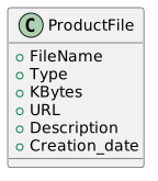
6.2.1. ProductFile Class
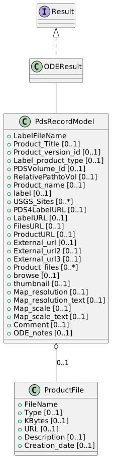
The ProductFile class represents a single downloadable file associated with a PDS product.
| Attribute | Description |
|---|---|
FileName |
Name of the file (without path). |
Type |
ODE classification: "Browse", "Product", "Label", etc. |
KBytes |
File size in kilobytes. |
URL |
Download URL for the file. |
Description |
Human-readable description of the file content. |
Creation_date |
ISO 8601 date string when the file was created. |
The ProductFile class provides metadata for individual files associated with PDS products, including classification, size, access information, and descriptive content.
6.2.2. PdsRecordModel Class
The PdsRecordModel class represents a full metadata record for a single planetary data product. It contains comprehensive information about the product, including identifiers, temporal data, geometry, observation details, and file access.

PdsRecordModel Core Attributes
| Attribute | Description |
|---|---|
ode_id |
An internal ODE product identifier. NOTE: This id is assigned by ODE when the product is added to the ODE metadata database. It is generally stable but can be changed when the ODE metadatabase is rebuilt. In general, this id should only be used shortly after acquisition. |
pdsid |
PDS Product Id |
ihid |
Instrument host id. See ODE for valid instrument host ids |
iid |
Instrument id. See ODE for valid instrument ids |
pt |
ODE Product type. This is ODE's product type. In general, it is obtained from the label but can be changed depending on whether a label has a product type, whether there are other products in the same instrument with the same product type in the label, etc. If this is not the same product type as in the label, the return will include a Label_Product_Type value as well. |
LabelFileName |
The file name of the product label |
Target_name |
Product target (example: Mars) |
Data_Set_Id |
PDS Data Set Id |
PdsRecordModel Temporal Attributes
| Attribute | Description |
|---|---|
Product_creation_time |
Product creation time (UTC) |
Product_release_date |
Product release date |
Observation_time |
Observation time (mid-point between the start and end of the observation) |
UTC_start_time |
Observation start time in UTC |
UTC_stop_time |
Observation end time in UTC |
PdsRecordModel Descriptive Attributes
| Attribute | Description |
|---|---|
Product_title |
Product title |
Product_version_id |
Product version |
Label_product_type |
Label product type (if it exists in the label and is different from the ODE_Product_Type) |
Description |
Label description |
Comment |
Any associated comment |
ODE_notes |
A note about how data has been entered into ODE |
PdsRecordModel Geometry Attributes
| Attribute | Description |
|---|---|
Easternmost_longitude |
Longitude 0-360 Easternmost longitude of the footprint |
Maximum_latitude |
Planetocentric maximum latitude of the footprint |
Minimum_latitude |
Planetocentric minimum latitude of the footprint |
Westernmost_longitude |
Longitude 0-360 Westernmost longitude of the footprint |
Footprint_geometry |
Cylindrical projected planetocentric, longitude 0-360 product footprint in WKT format. Only if there is a valid footprint. Note - this is a cylindrical projected footprint. The footprint has been split into multiple polygons when crossing the 0/360 longitude line and any footprints that cross the poles have been adjusted to add points to and around the pole. It is meant for use in cylindrical projects and is not appropriate for spherical displays. |
Footprint_C0_geometry |
Planetocentric, longitude -180-180 product footprint in WKT format. Only if there is a valid footprint. Note - this is a cylindrical projected footprint. The footprint has been split into multiple polygons when crossing the -180/180 longitude line and any footprints that cross the poles have been adjusted to add points to and around the pole. It is meant for use in cylindrical projects and is not appropriate for spherical displays. |
Footprint_GL_geometry |
Planetocentric, longitude 0-360 product footprint in WKT format. Only if there is a valid footprint. This is not a projected footprint. |
Footprint_NP_geometry |
Stereographic north polar projected footprint in WKT format. Only if there is a valid footprint. This footprint has been projected into meters in stereographic north polar projection. |
Footprint_SP_geometry |
Stereographic south polar projected footprint in WKT format. Only if there is a valid footprint. This footprint has been projected into meters in stereographic south polar projection. |
Footprints_cross_meridian |
T if the footprint crosses the 0/360 longitude line |
Pole_state |
String of "none", "north", or "south" |
PdsRecordModel Center Coordinates Attributes
| Attribute | Description |
|---|---|
Center_georeferenced |
T if the product has a footprint center |
Center_latitude |
Planetocentric footprint center latitude |
Center_longitude |
Longitude 0-360 center longitude |
Center_latitude_text |
Text found in the center latitude label keyword if the center latitude is not a valid number |
Center_longitude_text |
Text found in the center longitude label keyword if the center longitude is not a valid number |
PdsRecordModel Bounding Box Attributes
| Attribute | Description |
|---|---|
BB_georeferenced |
T if the product has a footprint bounding box |
Easternmost_longitude_text |
Text found in the easternmost longitude label keyword if the easternmost longitude is not a valid number |
Maximum_latitude_text |
Text found in the maximum latitude label keyword if the maximum latitude is not a valid number |
Minimum_latitude_text |
Text found in the minimum latitude label keyword if the minimum latitude is not a valid number |
Westernmost_longitude_text |
Text found in the westernmost longitude label keyword if the westernmost longitude is not a valid number |
Footprint_souce |
A brief description of where the footprint came from |
PdsRecordModel Observation Attributes
| Attribute | Description |
|---|---|
Observation_id |
Identifies a scientific observation within a dataset. |
Observation_number |
Monotonically increasing ordinal counter of the EDRs generated for a particular OBSERVATION_ID. |
Observation_type |
Identifies the general type of an observation |
Activity_id |
Label Activity id |
Start_orbit_number |
Start orbit number |
Stop_orbit_number |
End orbit number |
SpaceCraft_clock_start_count |
Spacecraft clock start |
SpaceCraft_clock_stop_count |
Spacecraft clock end |
PdsRecordModel Geometry-Derived Angles
| Attribute | Description |
|---|---|
Emission_angle |
Emission angle |
Emission_angle_text |
Emission angle text from the product label |
Phase_angle |
Phase angle |
Phase_angle_text |
Phase angle text from the product label |
Incidence_angle |
Incidence angle |
Incidence_angle_text |
Incidence angle text from the product label |
PdsRecordModel Map Projection Attributes
| Attribute | Description |
|---|---|
Map_resolution |
Map resolution |
Map_resolution_text |
Map resolution text from the product label |
Map_scale |
Map scale |
Map_scale_text |
Map scale text from the product label |
PdsRecordModel Solar/Atmospheric Attributes
| Attribute | Description |
|---|---|
Solar_distance |
Solar distance |
Solar_distance_text |
Solar distance text from the product label |
Solar_longitude |
Solar longitude |
Predicted_dust_opacity |
Predicted dust opacity |
Predicted_dust_opacity_text |
Predicted dust opacity text |
PdsRecordModel Archive/Volume Attributes
| Attribute | Description |
|---|---|
PDSVolume_Id |
Volume Id |
RelativePathtoVol |
The relative path from the volume root to the product label file |
Producer_id |
Producer id |
Product_name |
Product name |
label |
Complete product label for PDS3 product labels |
USGS_Sites |
A USGS site that this product’s footprint partially or completely covers |
PdsRecordModel URL Attributes
| Attribute | Description |
|---|---|
PDS4LabelURL |
Pointer to PDS4 XML label for PDS4 products |
LabelURL |
URL to the product label |
FilesURL |
URL to the product files |
ProductURL |
URL to the product |
External_url |
URL to an external reference to the product (e.g. the HiRISE site) |
External_url2 |
URL to a second external reference to the product (e.g. the HiRISE site) |
External_url3 |
URL to a third external reference to the product (e.g. the HiRISE site) |
PdsRecordModel File Attributes
| Attribute | Description |
|---|---|
Product_files |
Dictionary of file lists (ProductFile objects) associated with the product |
browse |
If there is an ODE browse image - returns a base64 string of the PNG image |
thumbnail |
If there is an ODE thumbnail image - returns a base64 string of the PNG image |
The PdsRecordModel class inherits from the O&M Observation model and extends it with comprehensive NASA-specific metadata for planetary data products, including temporal, geometric, observational, and archival information.
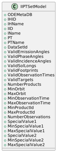
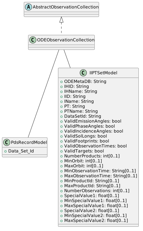
6.2.3. IIPTSetModel Class
The IIPTSetModel class represents a single instrument/product-type combination from an ODE query=iipt response. It provides metadata about the instrument, product type, and valid search parameters for that combination.
IIPTSetModel Attributes
| Attribute | Description |
|---|---|
ODEMetaDB |
ODE Meta DB – can be used as a Target input |
Instrument Host Id |
|
IHName |
Instrument Host Name |
Instrument Id |
|
IName |
Instrument Name |
Product Type |
|
PTName |
Product Type Name |
DataSetId |
Data Set Id |
IIPTSetModel Filter Validity Attributes
| Attribute | Description |
|---|---|
ValidEmissionAngles |
True if valid Emission Angles exist for searches |
ValidPhaseAngles |
True if valid Phase Angles exist for searches |
ValidIncidenceAngles |
True if valid Incidence Angles exist for searches |
ValidSolLongs |
True if valid Solar Longitudes exist for searches |
ValidFootprints |
True if valid Footprints exist for searches |
ValidObservationTimes |
True if valid Observation Times exist for searches |
ValidTargets |
Set of valid target values for the Target query parameter for a given instrument host, instrument, product type |
IIPTSetModel Statistical Attributes
| Attribute | Description |
|---|---|
NumberProducts |
Number of products with this instrument host/instrument/product type |
MinOrbit |
Minimum orbit value for all products with this instrument host/instrument/product type |
MaxOrbit |
Maximum orbit value for all products with this instrument host/instrument/product type |
MinObservationTime |
Minimum observation time value for all products with this instrument host/instrument/product type |
MaxObservationTime |
Maximum observation time value for all products with this instrument host/instrument/product type |
MinProductId |
Minimum product id value for all products with this instrument host/instrument/product type |
MaxProductId |
Maximum product id value for all products with this instrument host/instrument/product type |
NumberObservations |
Number of observation values found in the products (valid only for selected instrument host/instrument/product types) |
IIPTSetModel Special Values Attributes
| Attribute | Description |
|---|---|
SpecialValue1 |
Name or description of special value 1 unique to this product set |
MinSpecialValue1 |
Minimum special value 1 |
MaxSpecialValue1 |
Maximum special value 1 |
SpecialValue2 |
Name or description of special value 2 unique to this product set |
MinSpecialValue2 |
Minimum special value 2 |
MaxSpecialValue2 |
Maximum special value 2 |
The IIPTSetModel class provides metadata about instrument and product type combinations, including information about which search parameters are valid and statistical information about the products in each combination.
6.3. DOI
The Digital Object Identifier (DOI) is, strictly speaking, a persistent identifier system built on the Handle System: it guarantees that a digital resource remains uniquely and durably referenceable and citable. On its own, a DOI is only a string; what turns it into a reference data model is the metadata schema attached to it at registration time.
For research data, this schema is the DataCite Metadata Schema. It is the model the Pole relies on to expose its datasets in a citable, machine-readable form when minting DOIs. The current version is Schema 4.7 (released March 2026); it defines a small set of mandatory properties, completed by recommended and optional ones.
The DataCite schema defines six mandatory properties that must be supplied for every DOI:
| Property | Description |
|---|---|
Identifier |
The DOI itself, with |
Creator |
The main entities responsible for producing the resource (person, organization, or instrument team). Used to build the citation. |
Title |
The name by which the resource is known. |
Publisher |
The entity that holds, archives, publishes, or otherwise makes the resource available. For the Pole, this is the publishing organization (CNES/PDSSP). |
PublicationYear |
The year the resource was made publicly available. |
ResourceType |
The nature of the resource, with the mandatory controlled attribute |
Several recommended and optional properties are particularly relevant to planetary data: Date (with a dateType such as Collected, Created, or Issued), RelatedIdentifier (qualified links to related products or observations), GeoLocation (place name, point, box, or polygon footprint), FundingReference (funder, award, programme), Rights (licence), Version, Size, and Format.
Because the Pole already captures most of this information through EPN-TAP, STAC, and the O&M-derived models, DOI registration does not require a separate model: it is essentially a projection of existing fields onto the DataCite properties. The table below summarizes this projection.
| DataCite property | Source in the Pole’s model |
|---|---|
Identifier (DOI) |
DOI minted for the dataset or collection |
Creator |
Data producers ( |
Title |
|
Publisher |
Publishing organization (CNES/PDSSP) |
PublicationYear |
Year derived from |
ResourceType ( |
|
Date ( |
|
GeoLocation (polygon/box) |
|
RelatedIdentifier |
|
FundingReference |
|
Rights |
STAC |
Version |
|
Size / Format |
|
In this way, the DOI/DataCite layer provides the citability and long-term referenceability required by Open Science, while reusing the metadata already produced by the other reference models.
6.4. Open Science
Unlike the other sections of this chapter, Open Science is not a data model. It is a framework of principles: it does not define entities, attributes, or relationships, but rather states a set of requirements that any data model must satisfy in order to maximize the scientific and societal value of the data. These requirements are commonly summarized by the FAIR principles — Findable, Accessible, Interoperable, Reusable — formalized by Wilkinson et al. (2016).
For this reason, Open Science is not implemented in the Pole through a dedicated model. Instead, the FAIR principles are jointly realized by the reference models presented elsewhere in this document. The following table makes this correspondence explicit.
| FAIR principle | Realization in the Pole’s model |
|---|---|
Findable |
Persistent, unique identifiers (DOI/DataCite, |
Accessible |
Retrieval by identifier through open, standard protocols (HTTP, TAP); direct access to products ( |
Interoperable |
Shared vocabularies and formats: the O&M semantic anchor, UCDs for physical quantities, IAU nomenclature for targets, WKT geometries, MIME types ( |
Reusable |
Explicit licensing (STAC |
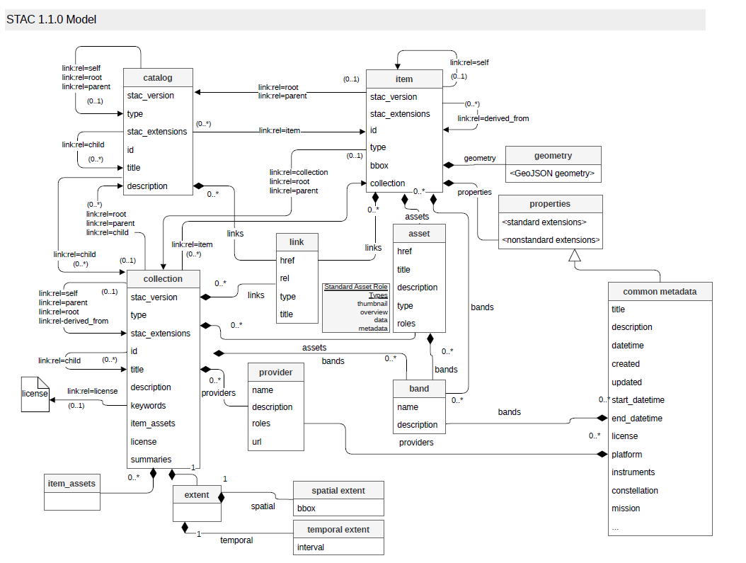
6.5. STAC
The SpatioTemporal Asset Catalog (STAC) data model is an open specification designed to enhance the discovery, accessibility, and interoperability of geospatial data. STAC provides a standardized way to describe and catalog geospatial assets, making it easier for users to search and utilize data from various providers. The model consists of four key components: Item, Collection, Catalog, and API. These components work together to organize and manage geospatial data, ensuring seamless integration into different systems and applications.
STAC supports a wide range of geospatial data types, including satellite imagery, SAR, LiDAR, hyperspectral imagery, point clouds, videos, and derived products like NDVI and Digital Elevation Models (DEMs). By adopting STAC, organizations can enhance the visibility and usability of their geospatial data, fostering better collaboration and innovation within the geospatial community. The STAC specification is widely adopted by major organizations such as NASA, USGS, Microsoft, ESRI, and Google, demonstrating its effectiveness and reliability in managing large-scale geospatial datasets.
The SpatioTemporal Asset Catalog (STAC) is a specification designed to improve the discoverability and accessibility of geospatial data. It provides a standardized way to describe geospatial assets, such as satellite imagery, drone data, and other observation data, using a simple and flexible JSON format. The STAC data model is built around three core components:
-
STAC Item: Represents a single asset, such as an image or a data file, along with its metadata. Each STAC item should include essential properties like the asset’s spatial and temporal extents.
-
STAC Collections: A grouping of STAC items that share common characteristics, such as data from the same sensor or mission. Collections provide additional metadata that describe the group as a whole, facilitating the discovery of related datasets.
-
STAC Catalog: Acts as a container for STAC items and collections. Catalogs can be nested, allowing for hierarchical organization of data. They provide structural elements to manage and navigate through large datasets.
STAC extensions enhance the core data model by adding domain-specific metadata fields. These extensions allow STAC to accommodate a wide range of geospatial data types and use cases.
Moreover, STAC can support more than just geolocated information. According to RFC 7946, section 3.2, the geometry can be null, enabling STAC to be used for any digital information by creating specific dictionaries. Here are some reasons for a null geometry:
-
Non-georeferenced Data: The item represents a resource without a spatial footprint, such as a metadata table or a document.
-
Unknown or Undetermined Geometry: During data ingestion, the geometry may not have been determined or extracted yet.
-
Confidentiality: Some data providers may intentionally hide the geometry for confidentiality reasons.
7. Comparison Reference Data Model with O&M
This chapter compares the reference data models with the O&M standard. Only EPN Core and NASA ODE are covered here: as discussed in Chapter 5, DOI/DataCite and Open Science are not data models in the same sense — DOI/DataCite is a citation metadata schema and Open Science is a framework of principles (FAIR) — and therefore do not map onto the O&M interfaces. The correspondences below present each EPN Core and ODE class as an extension of an O&M interface.
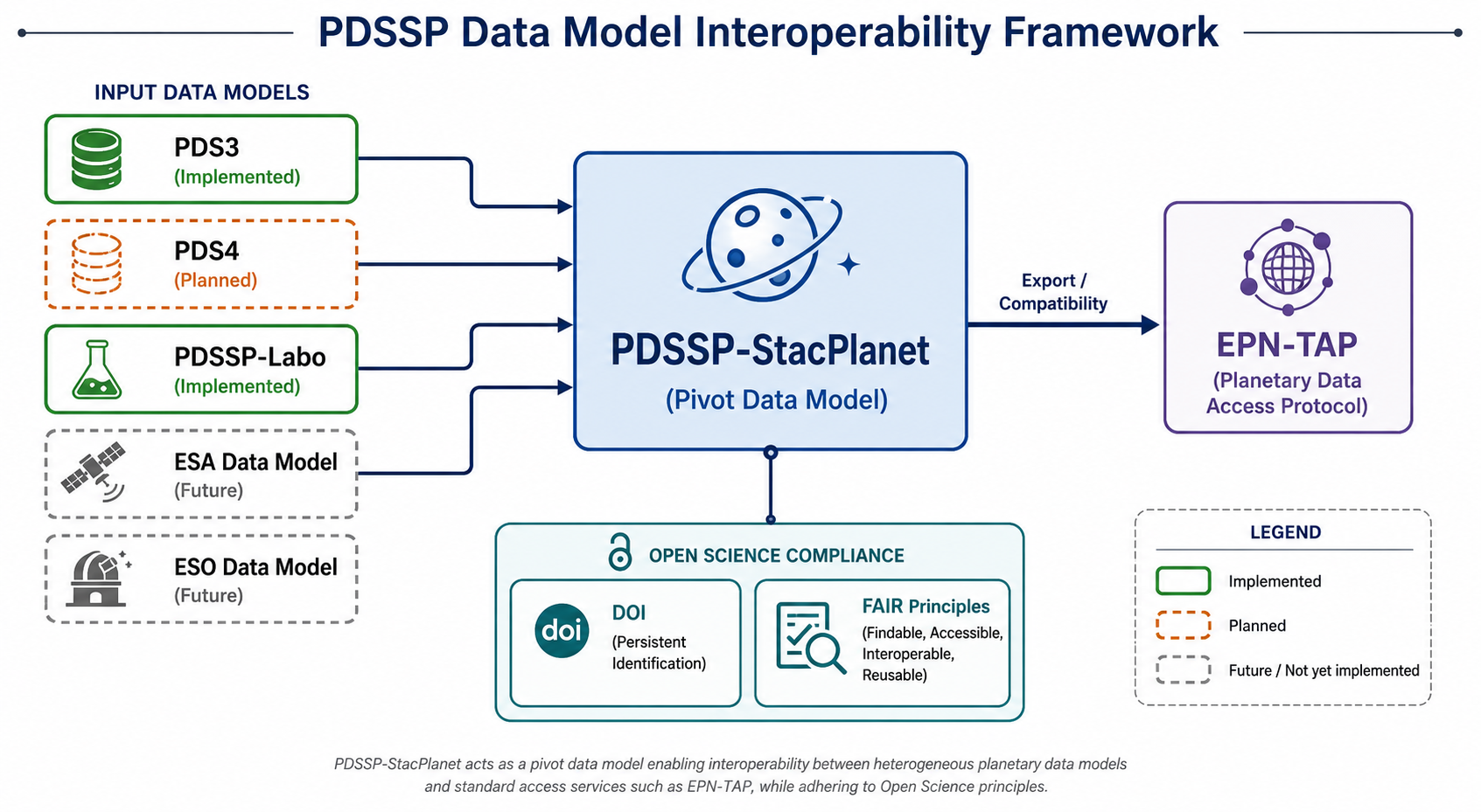
PDSSP-StacPlanet serves as a pivot data model that enables interoperability between heterogeneous planetary science data models and standard access protocols. Input models such as PDS3, PDSSP-Labo, and future ESA/ESO data models can be transformed into a common PDSSP-StacPlanet representation, which can then be exported to EPN-TAP. The model also supports Open Science principles through DOI-based data citation and compliance with FAIR (Findable, Accessible, Interoperable, Reusable) guidelines.
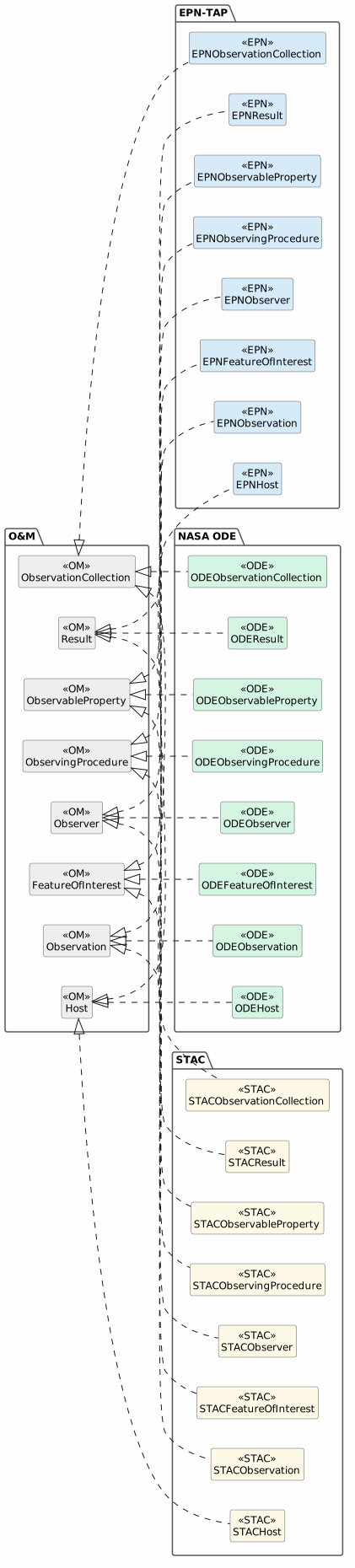
The diagram below gives a consolidated view of how the three reference models — EPN-TAP, NASA ODE, and STAC — each realize the seven O&M interfaces. Reading it by row shows which standard covers a given O&M concept; reading it by column shows the full O&M coverage of each standard.
7.1. EPN Core
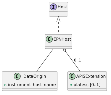
7.1.1. EPNHost Class
The EPNHost class implments the O&M Host interface to include the EPN-specific attributes for describing the platform carrying the instrument.
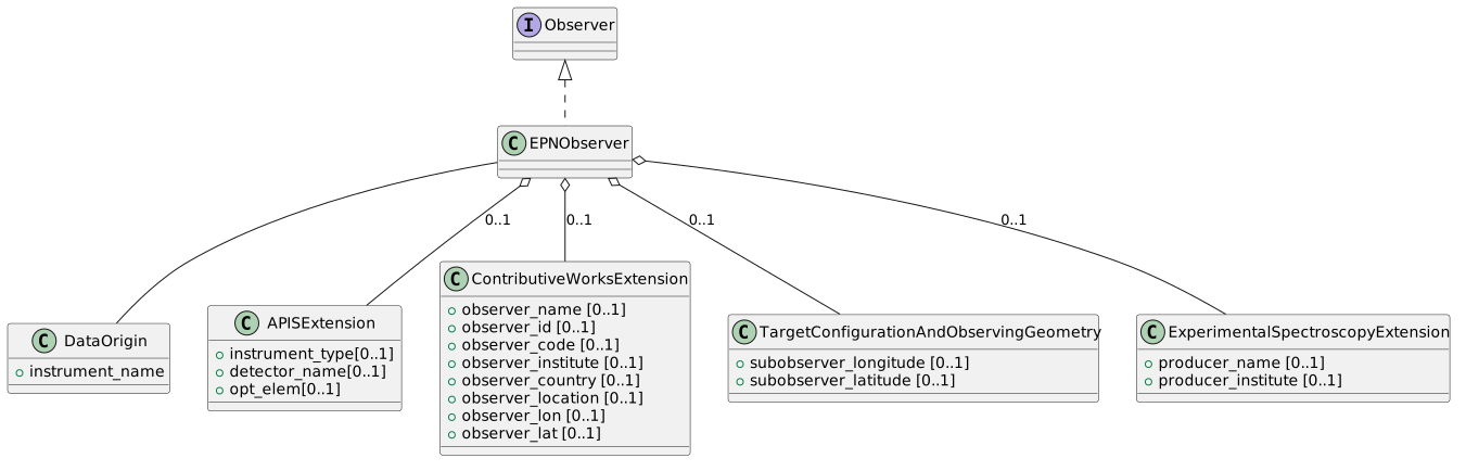
7.1.2. EPNObserver Class
The EPNObserver class implements the O&M Observer interface to include the EPN-specific attributes for describing the observer.
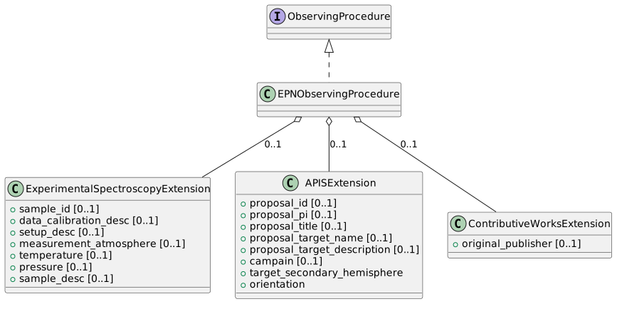
7.1.3. EPNObservingProcedure Class
The EPNObservingProcedure class implments the O&M ObservingProcedure interface to include the EPN-specific attributes for describing the observing procedure of the experiment.
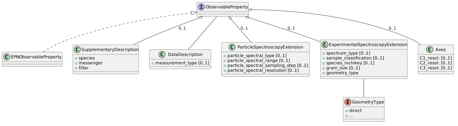
7.1.4. EPNObservableProperty class
The EPNObservableProperty class implements the O&M ObservableProperty interface to include EPN-specific attributes for describing the measurable physical quantities and properties contained in the data.
7.1.5. EPNFeatureOfInterest class
The EPNFeatureOfInterest class implements the O&M FeatureOfInterest interface to include EPN-specific attributes, distinguishing between the ultimate target and the proximate (specific) region being observed, in accordance with the O&M standard which defines both UltimateFeatureOfInterest and ProximateFeatureOfInterest concepts.
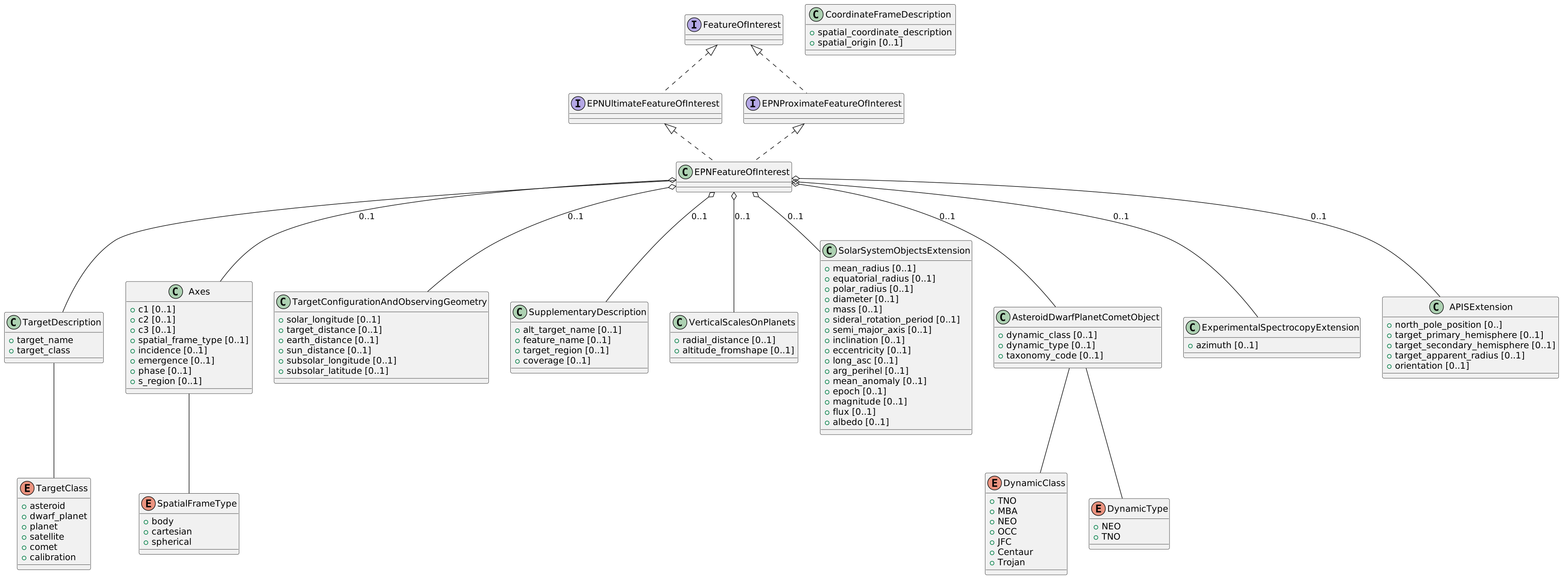
EPNUltimateFeatureOfInterest and EPNProximateFeatureOfInterest Classes
In the O&M standard, FeatureOfInterest has two important specializations: UltimateFeatureOfInterest and ProximateFeatureOfInterest. The EPN-TAP implementation follows this distinction:
-
UltimateFeatureOfInterest: Represents the primary/ultimate target of the observation (e.g., a planet, moon, or other celestial body).
-
ProximateFeatureOfInterest: Represents the specific region or point on/around the ultimate target that is being observed (e.g., a particular area on a planetary surface, atmospheric layer, or coordinate).
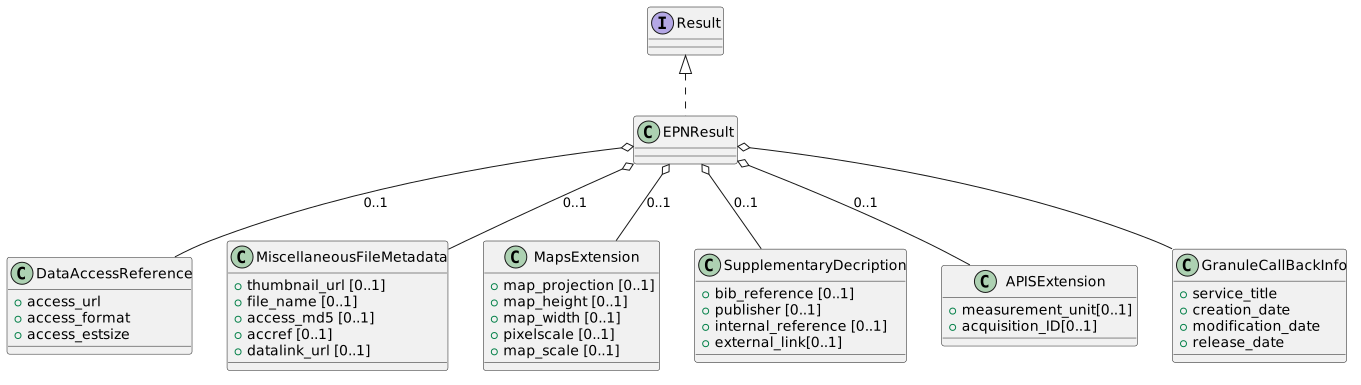
7.1.6. EPNResult class
The EPNResult class implements the O&M Result interface to include EPN-specific attributes for describing the data products and their access information in the context of the EPN-TAP protocol.
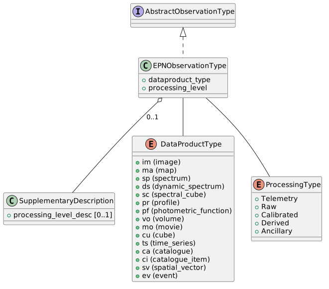
7.1.7. EPNObservationType
The EPNObservationType class implements AbstractObservationType to include EPN-specific attributes for describing observations within the EPN-TAP framework.
7.2. NASA ODE
This section details the mapping between the O&M (Observations & Measurements) standard interfaces and the NASA ODE (Orbital Data Explorer) model classes. Each ODE class is presented as an extension of the O&M interfaces, with ODE-specific attributes and associations tailored to NASA’s planetary data context.
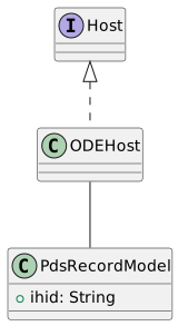
7.2.1. ODEHost
The ODEHost class implements the O&M Host interface to include ODE-specific attributes for describing the platform (e.g., spacecraft, observatory) carrying the instrument.
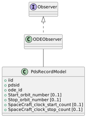
7.2.2. ODEObserver
The ODEObserver class implements the O&M Observer interface to describe the instrument or sensor used for observations, with ODE-specific attributes.
7.2.3. ODEObservingProcedure
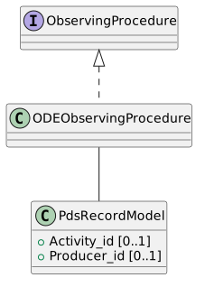
The ODEObservingProcedure implements the O&M ObservingProcedure interface to include ODE-specific details about observation procedures, such as calibration parameters or product types.
7.2.4. ODEObservableProperty
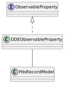
The ODEObservableProperty class extends the O&M ObservableProperty interface to describe the physical properties being measured, with ODE-specific attributes.
7.2.5. ODEFeatureOfInterest
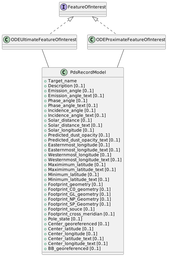
The ODEFeatureOfInterest class extends the O&M FeatureOfInterest interface to distinguish between the ultimate target (e.g., Mars) and the proximate region being observed (e.g., a specific crater).
7.2.6. ODEResult
The ODEResult class extends the O&M Result interface to describe data products and their access metadata in ODE.
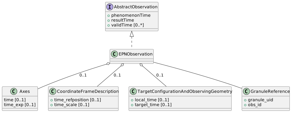
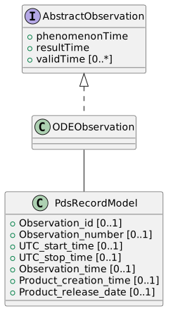
7.2.7. ODEObservation
The ODEObservation class extends AbstractObservation to include ODE-specific temporal and observational attributes.
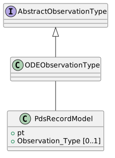
7.3. STAC
This section details the mapping between the O&M (Observations & Measurements) standard interfaces and the STAC (SpatioTemporal Asset Catalog) model classes. Each STAC class is presented as an extension of the O&M interfaces, with STAC-specific attributes and associations tailored to STAC.
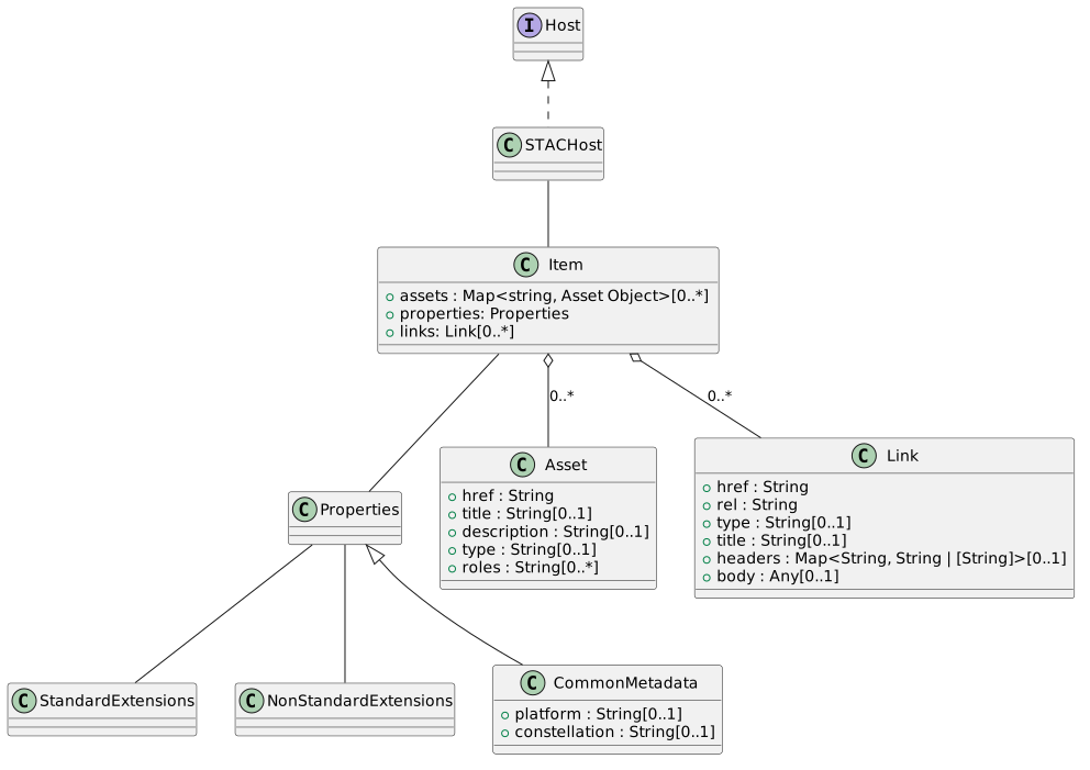
7.3.1. STACHost
The STACHost class implements the O&M Host interface to include STAC-specific attributes for describing the platform (e.g., spacecraft, observatory) carrying the instrument.
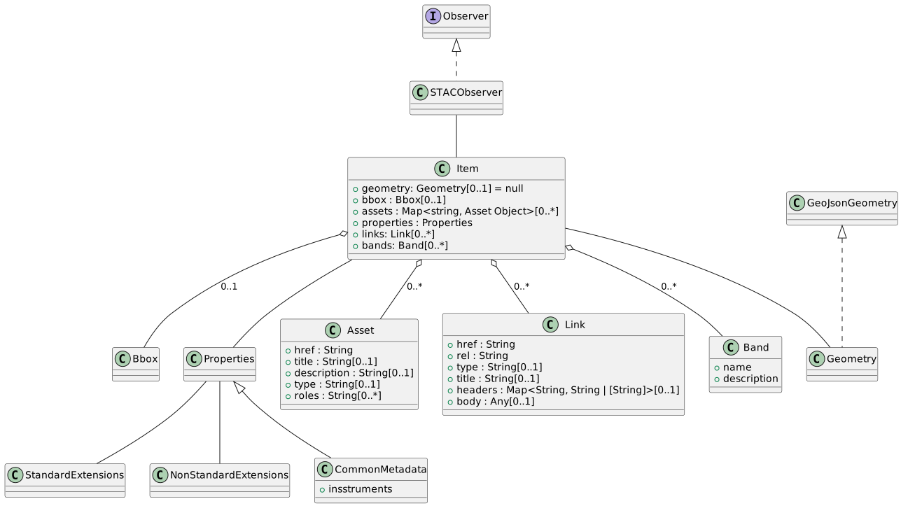
7.3.2. STACObserver
The STACObserver class implements the O&M Observer interface to describe the instrument or sensor used for observations, with STAC-specific attributes.
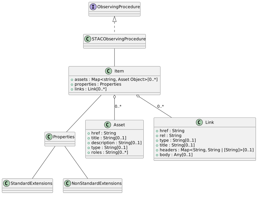
7.3.3. STACObservingProcedure
The STACObservingProcedure implements the O&M ObservingProcedure interface to include STAC-specific details about observation procedures, such as calibration parameters or product types.
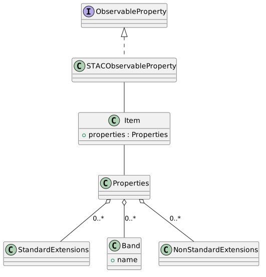
7.3.4. STACObservableProperty
The STACObservableProperty class extends the O&M ObservableProperty interface to describe the physical properties being measured, with STAC-specific attributes.
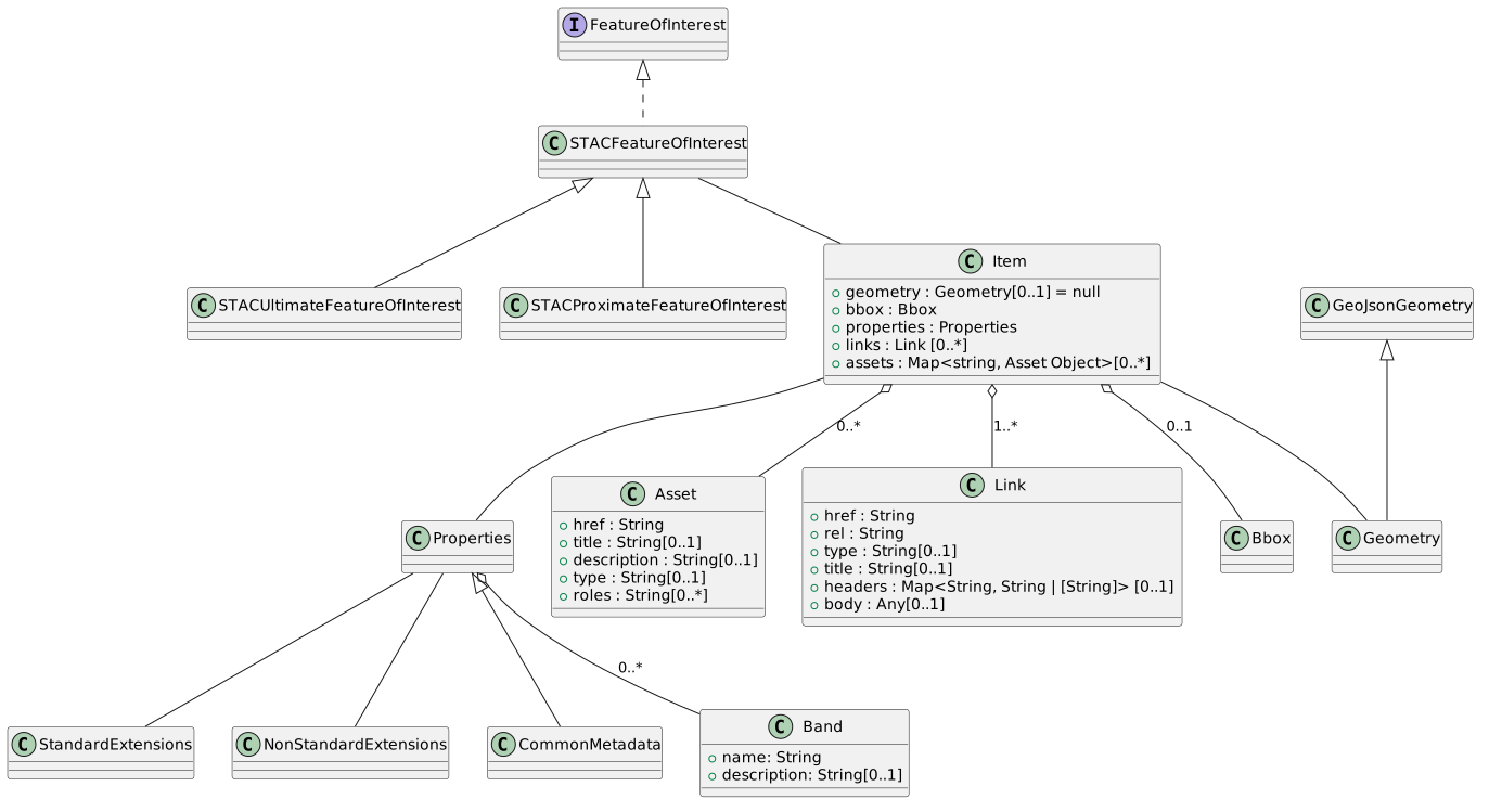
7.3.5. STACFeatureOfInterest
The STACFeatureOfInterest class extends the O&M FeatureOfInterest interface to distinguish between the ultimate target (e.g., Mars) and the proximate region being observed (e.g., a specific crater).
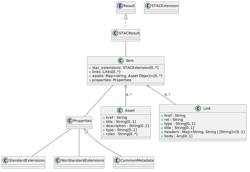
7.3.6. STACResult
The STACResult class extends the O&M Result interface to describe data products and their access metadata in STAC.
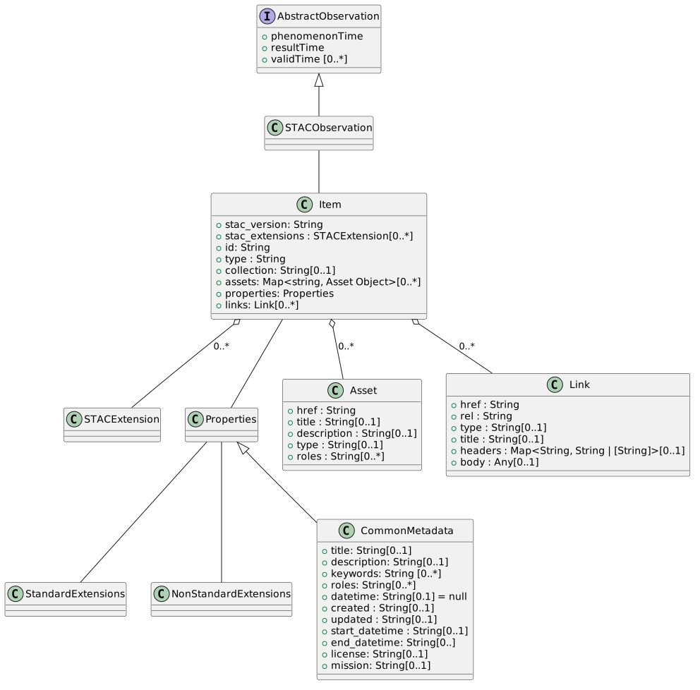
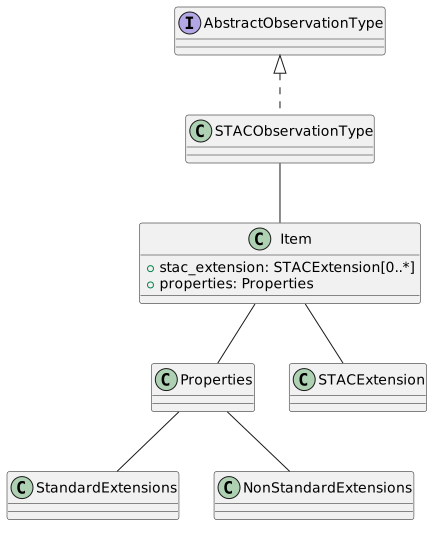
7.3.7. STACObservation
The STACObservation class extends AbstractObservation to include STAC-specific temporal and observational attributes.
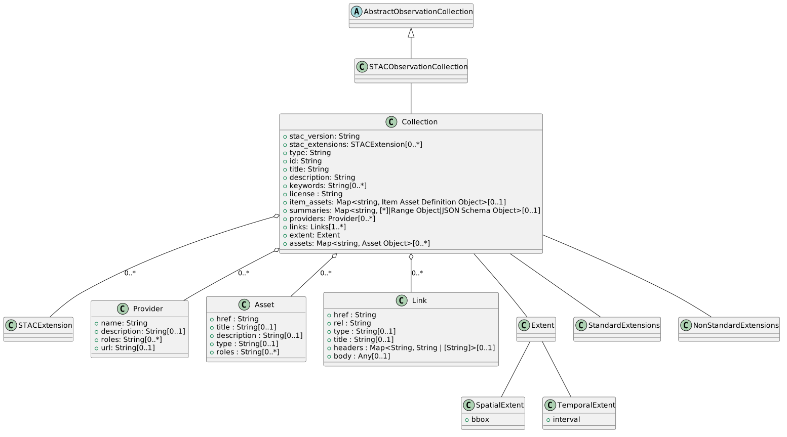
8. Mapping NASA ODE to STAC
This section is generated from the actual mapping code in ode-stac-proxy
(ode_plugin/response/{item_mapper,properties_builder,asset_builder,link_builder,
collection_mapper,stac_extensions,projection_resolver,taxonomy,utils}.py). Any
ODE field consumed nowhere in the mapper is still preserved: it is copied
verbatim onto item.properties as pdsode:<Field_name> (see PdsProxy.unused_fields()
in pds_proxy.py), so no science metadata is silently dropped even when a row
below says "Not mapped" or is absent from this table.
|
8.1. Host
| ODE | PDSSP STAC | Notes |
|---|---|---|
ihid |
item.properties.platform |
Resolved through |
Data_Set_Id (of the parent collection) |
item.properties.mission |
Not an item-level ODE field: resolved via |
8.2. Observer
| ODE | PDSSP STAC | Notes |
|---|---|---|
iid |
items.properties.instruments |
Single-element list. Resolved through |
ode_id |
item.id |
|
Start_orbit_number |
item.properties.sat:absolute_orbit |
|
Stop_orbit_number |
N/A |
Marked as consumed (without emitting a value) when it equals |
SpaceCraft_clock_start_count |
item.properties.pdsode:SpaceCraft_clock_start_count |
Not read by the mapper; passes through as an unconsumed-field residual. |
SpaceCraft_clock_stop_count |
item.properties.pdsode:SpaceCraft_clock_stop_count |
Not read by the mapper; passes through as an unconsumed-field residual. |
8.3. ObservingProcedure
| ODE | PDSSP STAC | Notes |
|---|---|---|
Activity_id |
item.properties.pdsode:Activity_id |
Not read by the mapper; passes through as an unconsumed-field residual. |
Producer_id |
item.properties.providers[0].name |
|
8.4. ObservableProperty
N/A
8.5. FeatureOfInterest
| ODE | PDSSP STAC | Notes |
|---|---|---|
Target_name |
item.properties.ssys:targets[0] |
|
Target_name / pt |
item.properties.ssys:target_class |
|
Description |
item.properties.description |
Also used as a last-resort source for |
Emission_angle / Emission_angle_text |
item.properties.view:off_nadir |
Fallback order: Emission_angle → float(Emission_angle_text) → None. |
Incidence_angle / Incidence_angle_text |
item.properties.view:incidence_angle |
Fallback order: Incidence_angle → float(Incidence_angle_text) → None. |
Phase_angle / Phase_angle_text |
item.properties.view:phase_angle |
Fallback order: Phase_angle → float(Phase_angle_text) → None. |
Solar_distance |
item.properties.pdssp:solar_distance |
Solar_distance_text is not mapped (no fallback logic in code) — passes through independently as |
Solar_longitude |
item.properties.pdssp:solar_longitude |
Solar_longitude_text is not mapped (no fallback logic in code) — passes through independently as |
Predicted_dust_opacity / Predicted_dust_opacity_text |
item.properties.pdsode:Predicted_dust_opacity / pdsode:Predicted_dust_opacity_text |
Neither field is read by the mapper. Unlike the angle fields above, there is no fallback logic between the numeric and |
Easternmost_longitude / Easternmost_longitude_text / Westernmost_longitude / Westernmost_longitude_text / Maximimum_latitude / Maximimum_latitude_text / Minimum_latitude / Minimum_latitude_text |
item.bbox |
|
Footprint_C0_geometry / Footprint_GL_geometry |
item.geometry |
Fallback order: Footprint_C0_geometry → Footprint_GL_geometry → None - Pole_state, Footprint_cross_meridian, Footprint_souce, Footprint_SP_geometry, Footprint_NP_geometry, Footprint_geometry, bbox |
Center_georeferenced |
Not mapped |
|
Center_latitude / Center_latitude_text |
item.properties.proj:centroid.lat |
|
Center_longitude / Center_longitude_text |
item.properties.proj:centroid.lon |
|
Target_name / iid / Data_Set_Id |
item.properties.proj:code |
Only added when both |
BB_georeferenced |
Not mapped |
8.6. Result
| ODE | PDSSP STAC | Notes |
|---|---|---|
LabelFileName |
Not mapped to a STAC field directly. Used, together with |
|
Product_Title |
item.properties.title |
Falls back to |
Product_version_id |
item.properties.version |
TBC with vesion |
Label_product_type |
item.properties.pdsode:Label_product_type |
Not read by the mapper; passes through as an unconsumed-field residual. |
PDSVolume_Id |
item.properties.pdsode:PDSVolume_Id |
|
RelativePathtoVol |
item.properties.pdsode:RelativePathtoVol |
Also consumed (without an explicit STAC field of its own) when reconstructing a relative |
Product_name |
item.properties.pdsode:product_name |
|
label |
item.properties.pdsode:label |
|
USGS_Sites |
item.properties.pdsode:USGS_Sites |
|
Product_lid / Bundle_lid / Collection_lid |
item.properties.pdsode:Product_lid / pdsode:Bundle_lid / pdsode:Collection_lid |
PDS4-only identifiers, not read by the mapper; pass through as unconsumed-field residuals when present. |
PDS4LabelURL |
item.assets['pds4_label'] |
|
LabelURL |
item.assets['label'] |
|
FilesURL |
items.links[rel="about"].href |
title is "All files for this product" and type is html |
ProductURL |
items.links[rel="about"].href |
title is "Product landing page" and type is html |
External_url |
items.links[rel="about"].href |
title is "External reference" and type is html. When the raw value is not already an absolute |
External_url2 |
items.links[rel="about"].href |
title is "External reference" and type is html. Same relative-URL reconstruction rule as |
External_url3 |
items.links[rel="about"].href |
title is "External reference" and type is html. Same relative-URL reconstruction rule as |
Product_files |
item.assets[FileName] |
Implemented in |
browse |
Not USED - image in base64 |
|
thumbnail |
Not USED - image in base64 |
|
Map_resolution |
item.properties.pdssp:map_resolution |
|
Map_resolution_text |
item.properties.pdsode:Map_resolution_text |
Not read by the mapper; passes through as an unconsumed-field residual (no fallback to |
Map_scale |
item.properties.pdssp:map_scale |
|
Map_scale_text |
item.properties.pdsode:Map_scale_text |
Not read by the mapper; passes through as an unconsumed-field residual (no fallback to |
Comment |
item.properties.pdsode:Comment |
|
ODE_notes |
item.properties.pdsode:ODE_notes |
|
FileName |
item.assets[Filename].title |
Also used as the asset dictionary key. Falls back to the literal |
Type |
item.assets[Filename].type_image |
Raw ODE type string, forwarded to |
KBytes |
items.assets[Filename].file:size |
Value * 1024 to covnert in Bytes |
URL |
items.assets[Filename].href |
|
Description |
items.assets[Filename].description |
|
Creation_date |
items.asset[Filename].creation_date |
The earliest |
8.7. Observation
| ODE | PDSSP STAC | Notes |
|---|---|---|
Observation_id |
item.properties.pdsode:Observation_id |
|
Observation_number |
item.properties.pdsode:Observation_number |
|
Observation_type |
item.properties.pdsode:Observation_type |
Not read by the mapper; passes through as an unconsumed-field residual. |
UTC_start_time |
item.properties.datetime and item.properties.start_datetime |
|
UTC_stop_time |
item.properties.end_datetime |
Direct mapping only, no fallback chain. |
Observation_time |
item.properties.datetime |
Fallback order: Observation_time → UTC_start_time → Product_creation_time → Product_release_date → earliest(Creation_date) across Product_files → date parsed from Description → None. |
Product_creation_time |
item.properties.datetime and item.properties.created |
|
Product_release_date |
item.properties.datetime and item.properties.published |
|
Description |
item.properties.datetime |
Last-resort fallback (lowest priority) when none of the date fields above nor any |
Product_files[].Creation_date |
item.properties.datetime |
Second-to-last fallback: the earliest ISO-8601-parseable |
N/A |
item.properties.datetime / created / published |
Any resolved datetime with year > 3000 is treated as invalid and coerced to |
8.8. ObservationType
| ODE | PDSSP STAC | Notes |
|---|---|---|
pt |
item.properties.ssys:targets[0] / item.properties.ssys:target_class |
|
N/A (inherited from the parent collection) |
item.properties.product:type |
Looked up as |
N/A (inherited from the parent collection) |
item.properties.processing:level |
Looked up as |
8.9. ObservationCollection
Collection building also consults two external, secondary lookups keyed
off DataSetId — not raw fields of the ODE IIPTSet response — via
explorer/pds_dsview_lookup.fetch() (PDS4 dataset-view: DOI, citation,
investigation/mission name) and explorer/pds_profile.get_profile() (PDS4
dataset profile: processing level, observing-system components, instrument
type). Rows below flag which values come from these enrichments rather than
directly from ODE.
|
| ODE | PDSSP STAC | Notes |
|---|---|---|
ODEMetaDB |
collection.keywords |
value = target:<ODEMetaDB> |
collection.keywords and collection.summaries.platform.append() |
value = platform:<IHID> |
|
IHName |
used in collection.title and collection.description |
|
collection.keywords and collection.summaries.instruments.append() |
value = instru:<IID> . Also used in collection.title and collection.description |
|
IName |
used in part of collection.title and used in part of collection.description |
|
collection.summaries.product_name.append() and collection.keywords |
value = type:<PT> in keywords; |
|
PTName |
collection.pdsode:product_name |
used in part of collection.title and used in part of collection.description |
DataSetId |
collection.pdsode:dataset_id and collection.keywords |
value = dataset:<DataSetId> in keywords (lowercased). Also the lookup key passed to the PDS4 dataset-view ( |
ValidEmissionAngles |
collection.keywords and collection.summaries['has_emission_angles'] = [True |
False] |
with_emission is displayed in keywords if ValidEmissionAngles is True else without_emission |
ValidPhaseAngles |
collection.keywords and collection.summaries['has_phase_angles'] = [True |
False] |
with_phase is displayed in keywords if ValidPhaseAngles is True else without_phase |
ValidIncidenceAngles |
collection.keywords and collection.summaries['has_incidence_angles'] = [True |
False] |
with_incidence is displayed in keywords if ValidIncidenceAngles is True else without_incidence |
ValidSolLongs |
collection.keywords and collection.summaries['has_solar_longitudes'] = [True |
False] |
with_ls is displayed in keywords if ValidSolLongs is True else without_ls |
ValidFootprints |
collection.keywords and collection.summaries['has_footprints'] = [True |
False] |
with_footprint is displayed in keywords if ValidFootprints is True else without_footprint |
ValidObservationTimes |
collection.keywords and collection.summaries['has_observation_times'] = [True |
False] |
with_obstime is displayed in keywords if ValidObservationTimes is True else without_obstime |
ValidTargets |
collection.target |
Read from the nested |
NumberProducts |
collection.pdsode:number_of_products |
|
MinOrbit |
collection.summaries["orbits"]["minimum"] |
|
MaxOrbit |
collection.summaries["orbits"]["maximum"] |
Same condition as MinOrbit above. |
MinObservationTime |
collection.summaries["observationTime"]["minimum"] |
Also used, together with MaxObservationTime, to build |
MaxObservationTime |
collection.summaries["observationTime"]["maximum"] |
Same condition as MinObservationTime above. |
MinProductId |
collection.summaries["productId"]["minimum"] |
Only set when both bounds are truthy. |
MaxProductId |
collection.summaries["productId"]["maximum"] |
Only set when both bounds are truthy. |
NumberObservations |
collection.pdsode:number_of_observations |
|
SpecialValue1 |
collection.pdsode:specialValue1 |
|
MinSpecialValue1 |
collection.summaries["specialValue1"]["minimum"] |
Only set when both MinSpecialValue1 and MaxSpecialValue1 are truthy. |
MaxSpecialValue1 |
collection.summaries["specialValue1"]["maximum"] |
Same condition as MinSpecialValue1 above. |
SpecialValue2 |
collection.pdsode:specialValue2 |
|
MinSpecialValue2 |
collection.summaries["specialValue2"]["minimum"] |
Only set when both MinSpecialValue2 and MaxSpecialValue2 are truthy. |
MaxSpecialValue2 |
collection.summaries["specialValue2"]["maximum"] |
Same condition as MinSpecialValue2 above. |
N/A (external: PDS4 dataset-view lookup keyed by DataSetId) |
collection.summaries['sci:publications'] |
Set to |
N/A (inherited by items) |
product:type |
|
N/A (inherited by items) |
processing:level |
|
8.10. STAC extensions
item.stac_extensions is derived purely from which properties/assets ended up
populated (response/stac_extensions.py), not from a dedicated ODE field:
-
Always declared:
ssysand the PDSSP schema (pdssp_schema). -
Declared when at least one property (on the item or on any asset) has a key starting with the given prefix:
product→productextension,sat→satextension,view→viewextension,file→fileextension,proj→projectionextension,processing→processingextension. -
Declared when the exact key is present on the item properties:
version→versionextension,published→timestampsextension.
collection.stac_extensions is a fixed list set at collection-build time
(ssys, scientific, processing, product), independent of which fields
are actually populated for a given collection.
9. Mapping STAC to EPN-TAP
9.1. Host
| EPN-TAP | PDSSP STAC | Datatype | Arraysize | UCD | Notes |
|---|---|---|---|---|---|
instrument_host_name |
item.properties.platform |
char |
* |
meta.id;instr.obsty |
9.2. Observer
| EPN-TAP | PDSSP STAC | Datatype | Arraysize | UCD | Notes |
|---|---|---|---|---|---|
instrument_name |
item.properties.instruments |
char |
* |
meta.id;instr |
properties.instruments is a list; see First element of a list-valued property. |
instrument_type |
|||||
detector_name |
|||||
opt_elem |
|||||
observer_id |
|||||
observer_code |
|||||
observer_institute |
|||||
observer_country |
|||||
observer_location |
|||||
observer_lon |
|||||
observer_lat |
|||||
subobserver_longitude |
|||||
subobserver_latitude |
|||||
producer_name |
collection.providers[role=producer].name |
char |
* |
meta.note |
|
producer_institute |
collection.providers[role=producer].name |
char |
* |
meta.note |
9.3. ObservingProcedure
| EPN-TAP | PDSSP STAC | Datatype | Arraysize | UCD | Notes |
|---|---|---|---|---|---|
sample_id |
|||||
data_calibration_desc |
|||||
setup_desc |
|||||
measurement_atmosphere |
|||||
temperature |
|||||
pressure |
|||||
sample_desc |
|||||
proposal_id |
|||||
proposal_pi |
|||||
proposal_title |
|||||
proposal_target_name |
|||||
proposal_target_description |
|||||
campain |
|||||
target_secondary_hemisphere |
|||||
orientation |
|||||
original_publisher |
9.4. ObservableProperty
| EPN-TAP | PDSSP STAC | Datatype | Arraysize | UCD | Notes |
|---|---|---|---|---|---|
species |
|||||
messenger |
|||||
filter |
item.properties.bands[0].name |
char |
* |
meta.id;instr.filter |
|
measurement_type |
item.properties.pdssp:measurement_type |
char |
* |
meta.code |
|
particle_spectral_type |
|||||
particle_spectral_range |
|||||
particle_spectral_sampling_step |
|||||
particle_spectral_resolution |
|||||
spectrum_type |
|||||
sample_classification |
|||||
species_inchikey |
|||||
grain_size |
|||||
geometry_type |
|||||
C1_resol |
item.properties.gsd |
double |
pos.resolution |
||
C2_resol |
item.properties.gsd |
double |
pos.resolution |
||
C3_resol |
9.5. FeatureOfInterest
| EPN-TAP | PDSSP STAC | Datatype | Arraysize | UCD | Notes |
|---|---|---|---|---|---|
target_name |
item.properties.ssys:targets[0] |
char |
* |
meta.id;src |
ssys:targets is a list; see First element of a list-valued property. |
target_class |
item.properties.ssys:target_class |
char |
* |
meta.code.class;src.class |
|
c1min |
min longitude of item.geometry.coordinates |
double |
pos.bodyrc.lon;stat.min |
See Bounding box of a GeoJSON geometry for the extraction algorithm. |
|
c1max |
max longitude of item.geometry.coordinates |
double |
pos.bodyrc.lon;stat.max |
||
c2min |
min latitude of item.geometry.coordinates |
double |
pos.bodyrc.lat;stat.min |
||
c2max |
max latitude of item.geometry.coordinates |
double |
pos.bodyrc.lat;stat.max |
||
c3min |
Not implemented: no third coordinate axis in the STAC geometries seen so far. |
||||
c3max |
Not implemented: no third coordinate axis in the STAC geometries seen so far. |
||||
spatial_frame_type |
char |
* |
pos.frame |
spatial_frame_type = body (a fixed value, not read from STAC — see Fixed (constant) columns) |
|
incidence |
item.properties.view:incidence_angle |
double |
pos.incidenceAng |
||
emergence |
no STAC equivalent |
||||
phase |
item.properties.view:phase_angle |
double |
pos.phaseAng |
||
s_region |
char |
* |
pos.outline;obs.field |
convert item.geometry.coordinates |
|
solar_longitude |
|||||
target_distance |
|||||
earth_distance |
|||||
sun_distance |
item.properties.pdssp:solar_distance |
double |
pos.distance;pos.heliocentric |
||
subsolar_longitude |
|||||
subsolar_latitude |
|||||
alt_target_name |
|||||
feature_name |
Inverted name resolver on coordinates |
||||
target_region |
item.properties.ssys:targets[0], lower-cased |
char |
* |
meta.id;src;obs.field |
Vocabulary: IVOA UAT. See First element of a list-valued property, lower-cased. |
coverage |
item.assets[key contains "moc"/"healpix"].href |
char |
* |
pos.outline;obs.field |
|
radial_distance |
computes from pos(planetocentric) to (planeotgraphic) |
||||
altitude_fromshape |
computes from the DTM |
||||
mean_radius |
|||||
equatorial_radius |
|||||
polar_radius |
|||||
diameter |
|||||
mass |
|||||
sideral_rotation_period |
|||||
semi_major_axis |
|||||
inclination |
|||||
eccentricity |
|||||
long_asc |
|||||
arg_perihel |
|||||
mean_anomaly |
|||||
epoch |
|||||
magnitude |
|||||
flux |
|||||
albedo |
|||||
dynamic_class |
|||||
dynamic_type |
|||||
taxonomy_code |
|||||
azimuth |
|||||
north_pole_position |
|||||
target_primary_hemisphere |
|||||
target_secondary_hemisphere |
|||||
target_apparent_radius |
|||||
orientation |
|||||
spatial_origin |
spatial_origin = Geocenter, item.properties.ssys:targets[0] |
||||
Spatial_coordinate_description |
item.properties.proj:code |
char |
* |
meta.code.class;pos.frame |
IAU CRS name (see CRS Registry). Filled in 2026-08-30: this row’s STAC mapping was previously blank even though it is implemented. |
9.6. Result
| EPN-TAP | PDSSP STAC | Datatype | Arraysize | UCD | Notes |
|---|---|---|---|---|---|
access_url |
item.assets[name][role=data].href |
char |
* |
meta.ref.url |
|
access_format |
item.assets[name][role=data].type |
char |
* |
meta.code.mime |
|
access_estsize |
item.assets[name][role=data].file:size |
long |
phys.size;meta.file |
See Picking the primary data asset. Filled in 2026-08-30: this row’s STAC mapping was previously blank even though it is implemented. |
|
thumbnail_url |
item.assets[name][role=thumbnail].href |
char |
* |
meta.ref.url;meta.preview |
|
file_name |
item.assets[name][role=data].title |
char |
* |
meta.id;meta.file |
|
access_md5 |
item.assets[name].file:checksum |
char |
* |
meta.checksum;meta.file |
|
datalink_url |
|||||
map_projection |
|||||
map_height |
|||||
map_width |
|||||
pixelscale |
pdssp:map_resolution |
double |
instr.scale |
||
map_scale |
pdssp:map_scale |
double |
pos.wcs.scale |
||
bib_reference |
item.properties.sci:doi |
char |
* |
meta.bib.doi |
|
publisher |
collection.providers[role=host].name |
char |
* |
meta.curation |
|
internal_reference |
|||||
external_link |
item.assets[role=metadata].href |
char |
* |
meta.ref.url |
|
service_title |
char |
* |
meta.title |
Not derived from a STAC field: fixed per proxy deployment. EPN-TAP2 mandatory. See Fixed (constant) columns. |
|
creation_date |
created |
char |
* |
time.creation |
|
modification_date |
updated |
char |
* |
time.update |
|
release_date |
published |
char |
* |
time.release |
timestamps extension |
9.7. Observation
| EPN-TAP | PDSSP STAC | Datatype | Arraysize | UCD | Notes |
|---|---|---|---|---|---|
time_min |
item.properties.start_datetime |
double |
time.start |
The time parameters in EPN-TAP are always provided in UTC and formatted in Julian Days (expressed in double precision). EPNCore uses standard JD to avoid ambiguity with time origin. start_datetime in STAC uses UTC time. If datetime is not null, time_min must be set to datetime. Conversion: Julian Date ↔ ISO 8601 datetime. |
|
time_max |
item.properties.end_datetime |
double |
time.end |
The time parameters in EPN-TAP are always provided in UTC and formatted in Julian Days (expressed in double precision). EPNCore uses standard JD to avoid ambiguity with time origin. start_datetime in STAC uses UTC time. Conversion: Julian Date ↔ ISO 8601 datetime. |
|
time_exp_min |
compute end_datetime-start_datetime, expressed as seconds |
||||
time_exp_max |
|||||
time_refposition |
item.properties.ssys:targets |
char |
* |
meta.id |
|
time_scale |
Set time_scale = UTC |
||||
local_time_min |
item.properties.ssys:local_time |
double |
time.phase;time.period.rotation;stat.min |
Must be converted |
|
local_time_max |
|||||
target_time_min |
item.properties.start_datetime |
char |
* |
time.start;src |
UTC time expressed as TIMESTAMP |
target_time_max |
item.properties.end_datetime |
char |
* |
time.end;src |
UTC time expressed as TIMESTAMP |
obs_id |
item.id |
char |
* |
meta.id |
|
granule_uid |
char |
* |
meta.id |
Convert granule_uid = id#md5(asset.href) |
10. The PDSSP Data Model
This chapter defines the data model of the Pole itself — the convergence point of the reference models studied so far. It is deliberately built on STAC so that it stays generic and standard-compatible, while adding a thin, declarative layer that makes it extensible and strictly controllable: the requiredness of fields, the set of allowed values, the supported objects, and the accepted files can all be configured per use case without ever modifying the STAC core.
10.1. Why STAC as the Pivot
Among the models studied in this document, none of the others is fit to serve as the single upstream source of truth:
-
O&M is a conceptual standard — a set of abstract interfaces (Observation, FeatureOfInterest, Observer…) with no single interchange serialization of its own. It is the right semantic anchor (Chapter 4) but not an implementable pivot format.
-
EPN-TAP is a single flat table of granules (Section 6.1): sufficient for a queryable export, too thin to preserve everything captured from an ODE record without loss.
-
DOI/DataCite metadata is, by design, a projection of fields already held elsewhere (Section 6.3) — it consumes the pivot, it cannot be the pivot.
-
ODE's own model is NASA-specific (Section 6.2) and not an open, community-governed catalog format.
STAC is the only candidate that combines four properties simultaneously:
-
Neutral, generic backbone. Catalog / Collection / Item / Asset / Link carries no domain bias toward any single input standard, so ingesting ODE today and ESA/ESO data tomorrow doesn’t require re-modeling the core.
-
A first-class extension mechanism.
stac_extensions+ versioned JSON Schema is designed to let a community add vocabulary (ssys,proj,pdssp:…) without forking the spec — exactly the layered schema/profile separation described below in Design Principles. None of the other candidates has an equivalent, client-enforceable mechanism. -
An existing ecosystem. STAC is adopted by NASA, USGS, Microsoft, ESRI, and Google (Section 6.5); any standard STAC client (STAC Browser, pystac, stac-fastapi) can read the Pole’s catalog for free, rather than the Pole building bespoke tooling.
-
Same standards lineage as O&M, with fewer constraints. STAC is an OGC community standard built on GeoJSON (RFC 7946), which permits
geometry: null— so non-georeferenced products (documents, tables, not-yet-located products) remain first-class citizens, unlike purely geospatial formats.
10.2. Design Principles
The model is organized in four superimposed layers, from the most generic and stable to the most specific and configurable:
-
STAC core (generic backbone). The Catalog / Collection / Item / Asset / Link structure is used unchanged. It is never specialized, which guarantees that any standard STAC client can read the Pole’s data. Following RFC 7946, the Item
geometrymay benull, so non-georeferenced resources (documents, tables, not-yet-located products) remain first-class. -
Standard extensions (shared vocabulary). A curated set of community STAC extensions provides the domain vocabulary, as established in Chapters 7 and 8 (
ssys,view,proj,processing,product,sat,file,sci,datacube,eo,timestamps…). Reusing published extensions is what keeps the model interoperable rather than proprietary. -
The
pdsspextension (custom keywords). Planetary concepts that no published extension covers (e.g.pdssp:phase_angle,pdssp:solar_longitude,pdssp:measurement_type) live in a single namespaced extension owned by the Pole, with its own JSON Schema. This is the controlled place to add custom keywords without polluting the core. -
The PDSSP Profile (configurable validation layer). A profile, published as a custom STAC extension JSON Schema and declared in each Item’s
stac_extensions, expresses the rules: which fields are required, which values are allowed, which objects are supported, and which files are accepted. Because it is a declared extension, it is enforced wherever the Item is validated — including client-side in STAC Browser. It carries no data — only constraints — so it can be tightened or relaxed per system without touching the data model.
| The separation between layers 1–3 (the schema: what can be described) and layer 4 (the profile: what must be true here) is the key design decision. It is what allows the global schema to stay generic while each deployment remains strictly controllable. |
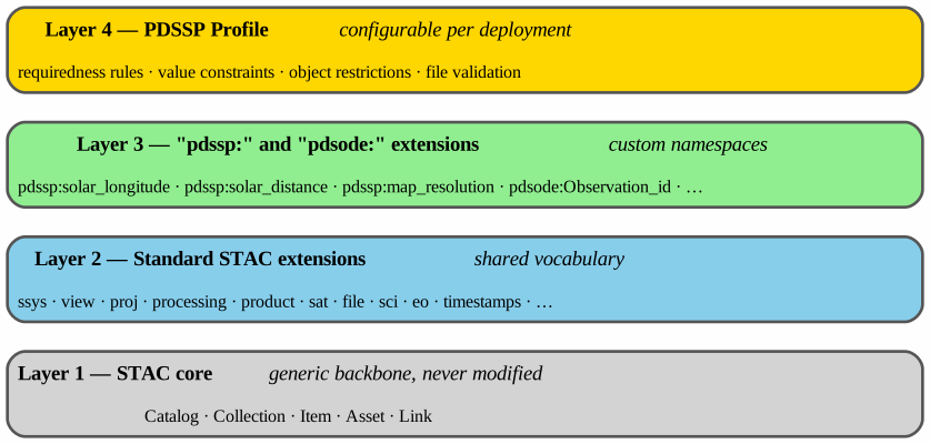
10.3. Architecture
The following UML diagram shows the STAC backbone, the extension bindings, and the configurable constraint layer that validates Items and Assets.
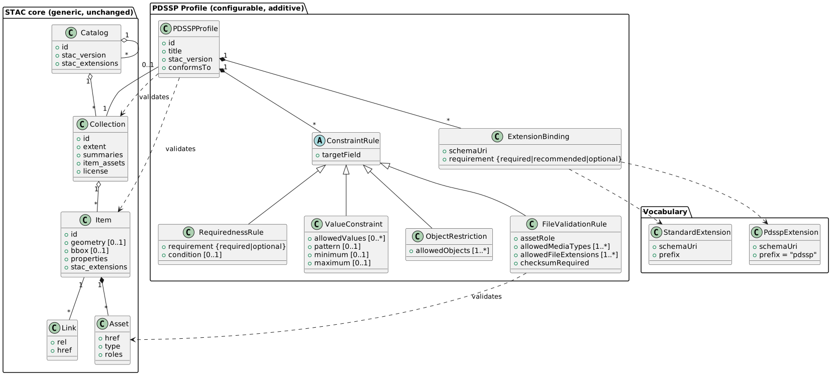
10.4. PDSSP Data Model (Class Diagram)
The following UML diagram shows the concrete PDSSP data model: how the PDSSP Profile adds planetary metadata to STAC Items and Collections through 5 mandatory extensions, with enumerated values.
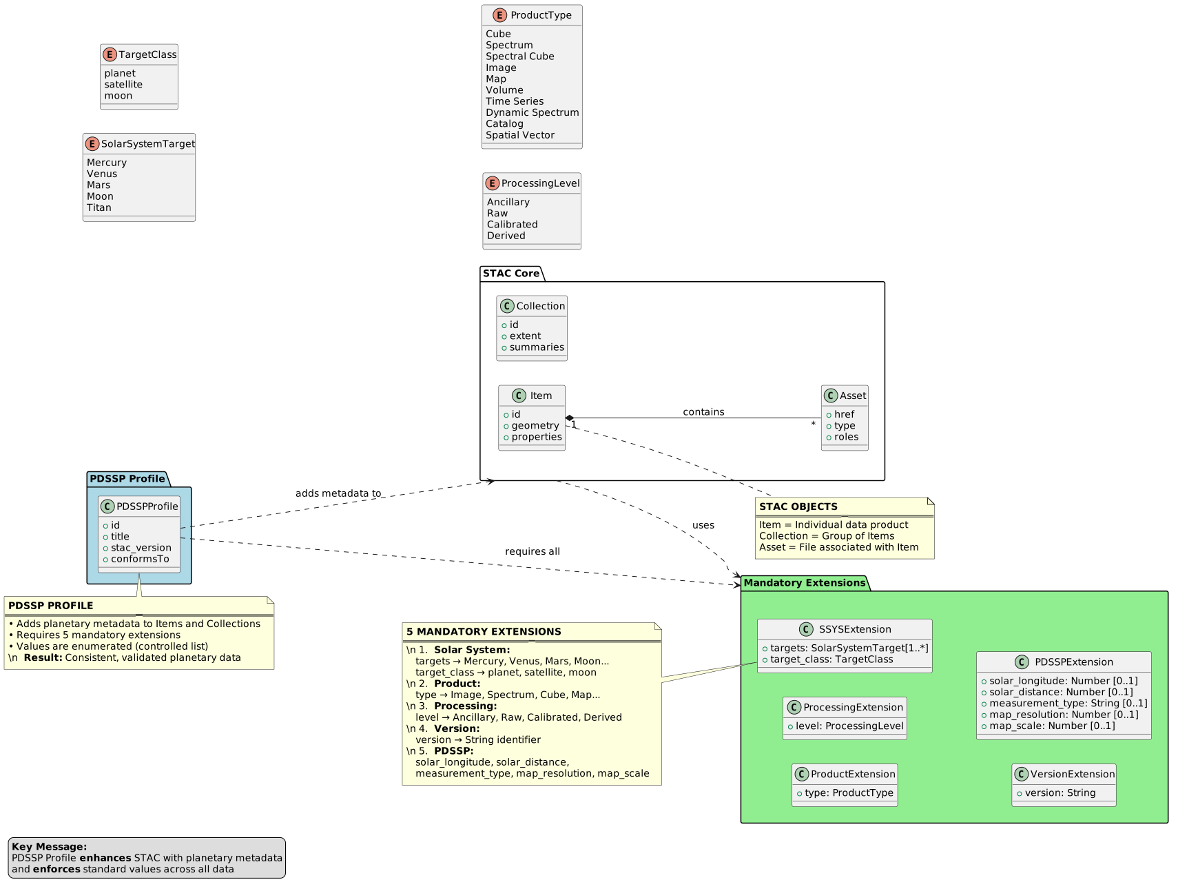
10.5. Extensibility and Strict Control
All controllability is expressed through the PDSSP Profile, so the four capabilities requested by the Pole map onto four rule types.
10.5.1. File validation by media type and extension
FileValidationRule constrains Assets by roles: it lists the allowedMediaTypes (the Asset type) and allowedFileExtensions (the file-name suffix of href), and can require a checksum (file:checksum). When the rule is expressed in the declared PDSSP schema, any Asset whose media type is not in the allowed list is flagged by STAC Browser at validation time.
10.5.2. Configurable requiredness (turning required into a rule)
Instead of a static required array baked into a schema, requiredness is expressed by RequirednessRule. Each rule targets a field, sets it required or optional, and may carry a condition. This makes required data-driven: for example, cube:dimensions becomes required only when product:type = sp. The profile compiler translates these rules into JSON Schema required arrays and if/then blocks.
10.5.3. Restricting allowed values
ValueConstraint restricts a field to an allowedValues enumeration, a pattern, or a numeric range (minimum/maximum). This compiles to JSON Schema enum, pattern, or range keywords. For descriptive (non-enforced) advertising of the same information at group level, the Collection summaries are populated in parallel.
10.5.4. Restricting supported objects for a given system
ObjectRestriction is a specialization aimed at the "restrict the objects supported in a given system" requirement: it limits a target field — typically ssys:targets — to an explicit allowedObjects list. A Mars-only deployment, for instance, restricts ssys:targets to ["Mars", "Phobos", "Deimos"]; any other body is flagged by STAC Browser as invalid.
10.5.5. Custom keywords
New custom keywords are declared and constrained directly in the pdssp extension schema (layer 3). Listing that schema in an Item’s stac_extensions is what makes the keywords validated by STAC Browser. This keeps the core untouched and the custom vocabulary versioned and discoverable.
In addition to pdssp:, the model uses a second namespace, pdsode:, dedicated to ODE-specific fields that have no equivalent in the STAC core or in any published community extension, but that retain scientific or operational value and are worth surfacing in STAC Items — for example for display in STAC Browser or downstream processing pipelines. These fields (pdsode:Observation_id, pdsode:PDSVolume_Id, pdsode:ODE_notes, etc.) are not semantically mapped to any STAC construct: they are preserved verbatim from the source ODE record. Like pdssp:, the pdsode: namespace is governed by its own JSON Schema, declared alongside the PDSSP profile schema in each Item’s stac_extensions.
10.6. The PDSSP Profile as a Declared STAC Extension
Because the Pole relies on STAC Browser to perform validation, the profile is not kept as a separate document but published as a custom STAC extension JSON Schema and declared in the stac_extensions array of every Item. STAC Browser (via stac-node-validator) fetches each schema URI listed in stac_extensions — custom extensions included — and validates the Item against it, so all the rules below are enforced client-side. Two practical conditions apply: the schema URL must be resolvable (no 404), and its host must allow cross-origin (CORS) requests, since the fetch happens in the browser.
The single schema below realizes all four capabilities for a Mars-imagery deployment: it defines and constrains the pdssp: custom keywords, requires the companion extensions, turns selected fields into required (including a conditional rule), restricts allowed values and supported objects, and limits accepted asset media types — without modifying the generic STAC core.
{
  "$schema": "http://json-schema.org/draft-07/schema#",
  "$id": "https://pdssp.github.io/stacplanet/v1.0.0/schema.json",
  "title": "PDSSP Planetary Data Schema for STAC Items and Collections",
  "description": "Schema defining PDSSP-specific keywords, constraints, and extensions for planetary imagery and data products. Applies to both STAC Items and Collections, with mandatory fields for solar system targets, product types, and processing levels. For items, ssys:targets, ssys:target_class, version, product:type, and processing:level are required. For collections, ssys:targets, ssys:target_class, product:type, and processing:level are required.",
  "type": "object",
  "allOf": [
    {
      "if": {
        "required": ["type"],
        "properties": {
          "type": {
            "const": "Feature"
          }
        }
      },
      "then": {
        "$ref": "#/definitions/item"
      }
    },
    {
      "if": {
        "required": ["type"],
        "properties": {
          "type": {
            "const": "Collection"
          }
        }
      },
      "then": {
        "$ref": "#/definitions/collection"
      }
    }
  ],
  "definitions": {
    "item": {
      "type": "object",
      "required": [
        "geometry",
        "properties",
        "stac_extensions"
      ],
      "properties": {
        "geometry": {
          "type": ["object", "null"]
        },
        "stac_extensions": {
          "type": "array",
          "if": {
            "properties": {
              "geometry": {
                "type": "null"
              }
            },
            "required": ["geometry"]
          },
          "then": {
            "allOf": [
              {
                "contains": {
                  "type": "string",
                  "pattern": "stac-extensions\\.github\\.io/ssys/"
                }
              },
              {
                "contains": {
                  "type": "string",
                  "pattern": "stac-extensions\\.github\\.io/product/"
                }
              },
              {
                "contains": {
                  "type": "string",
                  "pattern": "stac-extensions\\.github\\.io/processing/"
                }
              }
            ]
          },
          "else": {
            "allOf": [
              {
                "contains": {
                  "type": "string",
                  "pattern": "stac-extensions\\.github\\.io/ssys/"
                }
              },
              {
                "contains": {
                  "type": "string",
                  "pattern": "stac-extensions\\.github\\.io/projection/"
                }
              },
              {
                "contains": {
                  "type": "string",
                  "pattern": "stac-extensions\\.github\\.io/version/"
                }
              },
              {
                "contains": {
                  "type": "string",
                  "pattern": "stac-extensions\\.github\\.io/product/"
                }
              },
              {
                "contains": {
                  "type": "string",
                  "pattern": "stac-extensions\\.github\\.io/processing/"
                }
              }
            ]
          }
        },
        "properties": {
          "$ref": "#/definitions/fields"
        }
      }
    },
    "collection": {
      "type": "object",
      "required": [
        "stac_extensions",
        "ssys:targets",
        "ssys:target_class",
        "product:type",
        "processing:level"
      ],
      "properties": {
        "stac_extensions": {
          "type": "array",
          "allOf": [
            {
              "contains": {
                "type": "string",
                "pattern": "stac-extensions\\.github\\.io/ssys/"
              }
            },
            {
              "contains": {
                "type": "string",
                "pattern": "stac-extensions\\.github\\.io/processing/"
              }
            },
            {
              "contains": {
                "type": "string",
                "pattern": "stac-extensions\\.github\\.io/product/"
              }
            }
          ]
        },
        "ssys:targets": {
          "type": "array",
          "minItems": 1,
          "items": {
            "enum": ["Mercury", "Venus", "Mars", "Moon", "Titan"]
          },
          "description": "List of solar system targets covered by the collection. At least one target is required."
        },
        "ssys:target_class": {
          "type": "string",
          "enum": ["planet", "satellite"],
          "description": "Classification of the primary target (e.g., planet, satellite)."
        },
        "product:type": {
          "type": "string",
          "enum": [
            "Cube",
            "Spectrum",
            "Spectral Cube",
            "Image",
            "Map",
            "Volume",
            "Time Series",
            "Dynamic Spectrum",
            "Catalog",
            "Spatial Vector"
          ],
          "description": "Type of the data product. This field is mandatory."
        },
        "processing:level": {
          "type": "string",
          "enum": ["Ancillary", "Raw", "Calibrated", "Derived"],
          "description": "Processing level of the data product. This field is mandatory."
        }
      }
    },
    "fields": {
      "type": "object",
      "required": [
        "ssys:targets",
        "ssys:target_class",
        "version",
        "product:type",
        "processing:level"
      ],
      "properties": {
        "ssys:targets": {
          "type": "array",
          "minItems": 1,
          "items": {
            "enum": ["Mercury", "Venus", "Mars", "Moon", "Titan"]
          },
          "description": "List of solar system targets covered by the data. At least one target is required."
        },
        "ssys:target_class": {
          "type": "string",
          "enum": ["planet", "satellite"],
          "description": "Classification of the primary target (e.g., planet, satellite)."
        },
        "version": {
          "type": "string",
          "minLength": 1,
          "description": "Version identifier for the data product. This field is mandatory for items."
        },
        "product:type": {
          "type": "string",
          "enum": [
            "Cube",
            "Spectrum",
            "Spectral Cube",
            "Image",
            "Map",
            "Volume",
            "Time Series",
            "Dynamic Spectrum",
            "Catalog",
            "Spatial Vector"
          ],
          "description": "Type of the data product. This field is mandatory."
        },
        "processing:level": {
          "type": "string",
          "enum": ["Ancillary", "Raw", "Calibrated", "Derived"],
          "description": "Processing level of the data product. This field is mandatory."
        },
        "pdssp:solar_longitude": {
          "type": "number",
          "description": "Solar longitude of the target at the time of observation (optional)."
        },
        "pdssp:solar_distance": {
          "type": "number",
          "description": "Distance from the Sun to the target at the time of observation, in astronomical units (optional)."
        },
        "pdssp:map_resolution": {
          "type": "number",
          "description": "Spatial resolution of the map, in meters per pixel (optional)."
        },
        "pdssp:map_scale": {
          "type": "number",
          "description": "Scale of the map (optional)."
        }
      }
    }
  }
}
When an Item declares https://pdssp.cnes.fr/stac/pdssp/v1.0.0/schema.json in its stac_extensions, STAC Browser validates it against this schema and reports any breach directly in its validation panel: a missing required field, a target outside the supported planets in PDSSP, a processing:level outside the allowed set, a null geometry. The same generic STAC Item, published with a different PDSSP extension schema, can serve an entirely different mission under different rules — which is precisely the flexibility, extensibility, and strict, browser-side control sought for the Pole.
The PDSSP extension schemas (pdssp: and pdsode:) are maintained and versioned in the STACPlanet GitHub repository. Each released version is published to GitHub Pages at a stable, CORS-enabled URL, which is the URL that must appear in stac_extensions for STAC Browser to fetch and validate against it. The version embedded in the URL (v1.0.0, v1.1.0, …) is the contract: Items already in production are never broken by a new release because they reference an immutable versioned URL.
11. Reference Documents
This section lists the normative documents, standards, and frameworks referenced throughout this document.
11.1. OGC and ISO Standards
| Reference | Title | Version/Date | URL |
|---|---|---|---|
ISO 19156:2011 |
Geographic information – Observations and Measurements |
2011 |
|
OGC 07-022r1 |
Observations and Measurements (O&M) - XML Implementation |
2.0 |
|
SpatioTemporal Asset Catalog |
1.0 |
11.2. NASA Models and Services
| Reference | Title | Version/Date | URL |
|---|---|---|---|
NASA ODE |
Orbital Data Explorer Data Model |
N/A |
|
PDS4 |
Planetary Data System Version 4 Standards |
1.x |
11.3. IVOA Standards
| Reference | Title | Version/Date | URL |
|---|---|---|---|
Europlanet Table Access Protocol |
1.1 |
||
Table Access Protocol |
1.1 |
||
Data Access Layer Interface |
1.1 |
||
Universal Worker Service |
1.0 |
11.4. Open Science and Identifiers
| Reference | Title | Version/Date | URL |
|---|---|---|---|
The FAIR Guiding Principles for scientific data management and stewardship. Sci. Data 3:160018, doi: 10.1038/sdata.2016.18 |
2016 |
||
FAIR Principles |
Findable, Accessible, Interoperable, Reusable |
2016 |
|
French national Open Science portal — FAIR sub-criteria |
N/A |
||
W3C PROV-Overview |
An Overview of the PROV Family of Documents |
2013 |
|
DataCite Schema |
DataCite Metadata Schema |
4.7 |
|
DOI System |
Digital Object Identifier System |
N/A |
|
Handle System |
Handle System Specification |
N/A |
11.5. Other References
| Reference | Title | Version/Date | URL |
|---|---|---|---|
RFC 7946 |
The GeoJSON Format |
2016 |
|
IAU 2009 |
IAU/IAG Working Group on Cartographic Coordinates and Rotational Elements |
2009 |
Index
Appendix A: EPN-TAP ↔ STAC Conversion Algorithms
The mapping tables in Mapping STAC to EPN-TAP reference several
non-trivial conversions between an EPN-TAP parameter and its STAC source.
This appendix describes each one as a plain algorithm, independent of any
particular implementation, so the mapping stays meaningful to a reader
without access to the proxy’s source code. A reference implementation of
every algorithm below exists as a Python function in the epntap2cql2
proxy’s converters.py module.
Julian Date ↔ ISO 8601 datetime
EPN-TAP’s time_min/time_max are Julian Dates (UTC, double precision);
STAC’s start_datetime/end_datetime are RFC 3339 / ISO 8601 strings.
EPN-TAP → STAC (Julian Date to ISO 8601):
-
Let
JD_UNIX_EPOCH = 2440587.5(the Julian Date of 1970-01-01T00:00:00Z). -
unix_seconds = (jd - JD_UNIX_EPOCH) × 86400 -
Convert
unix_seconds(a Unix timestamp) to a UTC calendar date-time. -
Format it as an ISO 8601 string with a trailing
Z(e.g.2007-06-05T22:50:23.754900Z).
STAC → EPN-TAP (ISO 8601 to Julian Date): the inverse —
-
Parse the ISO 8601 string into a UTC date-time (a bare
Zsuffix is read as+00:00; a string with no timezone at all is assumed UTC). -
unix_seconds= seconds since 1970-01-01T00:00:00Z. -
jd = unix_seconds / 86400 + JD_UNIX_EPOCH
First element of a list-valued property
Several STAC properties are lists where EPN-TAP expects a single value
(e.g. ssys:targets, instruments). Algorithm: if the value is a list,
return its first element (or nothing, if the list is empty); otherwise
return the value unchanged.
First element of a list-valued property, lower-cased
Same as First element of a list-valued property, then lower-case the result if it is a
string. Used for target_region from ssys:targets, since the target
region controlled vocabulary (see the
IVOA UAT) uses lower
case terms.
Comma-join a list-valued property
Alternative to First element of a list-valued property when every element should be kept
rather than only the first: join every element of the list into one
string with ", " as the separator.
Name of the first spectral band
For EPN-TAP’s filter from a STAC bands (or eo:bands) property: each
entry of that list is an object with (at least) a name field. Return the
name of the first entry, or nothing if the list is empty or absent.
Picking the primary data asset
Unlike EPN-TAP’s single access_url/access_format/access_estsize/
access_md5/file_name columns, a STAC item’s assets object is keyed
by an arbitrary, per-item file name — there is no fixed key such as
assets.data. The algorithm below picks one asset to represent "the"
data product for that item, used by every one of those EPN-TAP columns:
-
Consider every asset whose
roleslist contains"data". -
If at least one such asset exists, keep only those; otherwise, fall back to considering every asset regardless of role.
-
Among the candidates, pick the one with the largest
file:size(missing/absent size counts as 0). -
Read the requested attribute off that one asset:
href(→access_url),type(→access_format),file:size(→access_estsize),file:checksum(→access_md5), ortitle(→file_name).
If this heuristic picks the wrong file for a given collection (e.g. a
browse/label file that happens to also be tagged "data"), it should be
tuned per collection rather than universally.
Picking an asset by role
For thumbnail_url and external_link: return the href of the first
asset (in the item’s own key order) whose roles list contains
"thumbnail" (resp. "metadata"). Unlike Picking the primary data asset, no
size-based tie-breaking is applied, since there is normally at most one
asset of these roles per item.
MOC/HEALPix coverage asset
For coverage: return the href of the first asset (in the item’s own
key order) whose key contains "moc" or "healpix" (case-insensitive) — a PDSSP-specific naming convention for a MOC/HEALPix footprint file,
rather than a STAC roles entry.
Bounding box of a GeoJSON geometry
For c1min/c1max/c2min/c2max (and, were a third axis ever needed,
c3min/c3max) from an item’s geometry (GeoJSON Point, Polygon,
MultiPolygon, …):
-
Recursively walk the geometry’s
coordinatesarray. At each level: if the current array is a flat list of 2 (or 3) numbers, it is one coordinate pair/triple[lon, lat(, alt)]— record it and stop recursing into it; otherwise recurse into each of its elements. This works uniformly for every GeoJSON geometry type without assuming a fixed nesting depth. -
c1min/c1max= the minimum/maximum of the first component (longitude) across every recorded coordinate. -
c2min/c2max= the minimum/maximum of the second component (latitude). -
If no coordinate could be extracted (missing/empty geometry), the result is absent, not zero.
Per EPN-TAP2’s own table of spatial UCDs (conditioned on
spatial_frame_type), with spatial_frame_type = body (this proxy’s
fixed value, see Fixed (constant) columns) the correct UCDs are
pos.bodyrc.lon;stat.min/stat.max for c1min/c1max and
pos.bodyrc.lat;stat.min/stat.max for c2min/c2max.
Fixed (constant) columns
Some EPN-TAP columns have no variable STAC source at all — either
because the value is the same for every granule this proxy serves (e.g.
spatial_frame_type, always "body") or because it identifies the
service rather than any one granule (service_title, EPN-TAP2
mandatory, set to the service’s own title). Algorithm: none — the
configured fixed value is returned for every row, unconditionally.
Value derived from the collection, not the item
publisher, producer_name and producer_institute are the same for
every item of one STAC collection, but differ between collections — so,
unlike a per-item conversion, this one is resolved once per collection
rather than once per row:
-
Read the STAC Collection object’s
providerslist (present directly in the/collectionslisting response; no extra request is needed). -
Return the
nameof the first provider entry whoseroleslist contains the requested role —"host"forpublisher,"producer"forproducer_name/producer_institute(STAC has no separate "institute" field, so both read the same provider’sname). -
If no provider has that role, the column has no value for that collection.